GOVERNMENT OF NORTHERN IRELAND
MINISTRY OF FINANCE
ANCIENT MONUMENTS OF NORTHERN IRELAND
Volume II: Not in State Care
BELFAST
HER MAJESTY'S STATIONERY OFFICE
1963
Printed in Northern Ireland for Her Majesty's Stationery Office by W. & G. Baird, Ltd., Belfast. Wt.8136. K20. 12/63
PREFACE TO THE SECOND EDITION
The introduction to this volume, which gives a concise account of the archaeology and architecture of Ulster from the earliest times to the beginnings of the nineteenth century, is the work of Professor E. M. Jope, of the Department of Archaeology, Queen's University Belfast; he has carefully revised it for the present edition.
The monuments listed at the end of the book are in private ownership, and the consent of the owners or occupiers of the land should be obtained before visiting them. For ease of reference they have been numbered from 1 to 96, and these figures are constantly cited, in brackets, throughout Professor Jope's introduction. They are also used to identify the sites on the map at the end of the book. Ground plans are reproduced throughout at a scale of 30 feet to an inch.
Monuments in State care are described in Volume I,* which includes a number that were previously listed in the first edition of the present volume, but which have since been acquired by the Ministry of Finance.
* Ancient Monuments of Northern Ireland. Volume I: In State Care. (H.M.S.O., Belfast, price 6s. 0d., by post 6s. 6d.)
SOURCES OF ILLUSTRATIONS
Courtesy of Director of Ulster Museum (R. J. Welch collection): plates I, 2, 5, and 10. Royal Air Force: plates 4a, 4b, and 6. E. M. Jope: Plates 13b, 14a, 14b, and 15a. A. E. P. Collins: Plates 3c, Sb, 9b, 11b, and 13a. E. A. Jolmson: Plates 9a and 11a. R. H. Hewitt: plate 16a. A. & C. Photography: plate 16b. Courtesy of British Museum, London: plate 12. Courtesy of Ulster Journal of Archaeology: plates 3a, 3b, and 8a. H. A. Meek: plates 7 and 8b. Northern Ireland Tourist Board: plate 15b.
The illustration of Bangor Tower (No. 49) on the cover is after an engraving by Evans of a drawing by J. H. Burgess, which appeared in Ireland, its Scenery, Character, etc., by Mr. and Mrs. S. C. Hall (London, 1840).
ANCIENT MONUMENTS OF NORTHERN IRELAND
A feeling of continuity with the past is a strong background to Ulster life. Deep roots, extending back many centuries before the Christian era, make the study and preservation of its ancient monuments a matter of importance to the life of the Province even to-day. These monuments cannot fail to stimulate interest in this cultural heritage, and not only in the minds of Ulstermen. They are also attracting, in ever-increasing measure, the attention of visitors and students from overseas.
This booklet is intended to deal primarily with the more important ancient monuments not in the ownership or under the guardianship of the Ministry of Finance, and it has been thought desirable to sketch in these pages, if only in broad outlines, a picture of life in Ulster from the Stone Age down to modern times, as revealed by its archaeology.
THE STONE AGE
The earliest known activity of man in Ulster was in the Mesolithic Period, or Middle Stone Age, which followed the gradual retreat of the glaciers at the end of the Ice Age -- about the seventh millennium B.C. These early men lived entirely on the products of nature, such as fruits and shell-fish, and were active mainly along the coasts and lake shores. In Ulster no dwellings or burials of this age have been found, and little survives except flint implements, many of which, much battered and rolled, were cast up in storm beaches along the shores in later mesolithic times. Remains surviving in Scandinavia, such as sledges and ski-runners, and recent finds in northern England, show that life in this period was much fuller than flint implements alone would suggest. The North Channel already existed as a sea passage between Britain and Ireland, and the mesolithic people were able to cross such expanses of sea, probably in hide-covered and wicker-framed boats resembling the curraghs still in use round the western coasts of Ireland.
Everyday Life in Neolithic Times. The succeeding Neolithic Period, or New Stone Age, which began here towards the end of the fourth millennium B.C. is marked by the appearance of immigrant groups who lived by stock-raising and agriculture, to supplement the gathering from Nature which was the sole subsistence of the preceding age. From a study of pollen grains preserved in damp deposits, and of actual impressions of grain on the sides of pottery vessels, the making of which was also introduced at this period, it is known that both wheat and barley were grown, and saddle-querns were used to grind the grain. Animal bones from excavations on Neolithic sites show that domestic animals were kept. Some habitation sites of this period survive, but the remains are scanty. They have recently become the subject of close study, and it is already clear that both round and rectangular houses were being built, with low stone or mud walls and timber roof-supports. Lakeside dwellings, and artificially constructed islands (known as crannogs) such as at Island MacHugh, Co. Tyrone (87), and Enagh (near Londonderry City) (64), were already being used (compare Plate 5). The old food-gathering habits persisted, however, in the form of strand-looping along the shores and in the valley of the lower Bann. They have, in fact, lingered almost to the present day. The Neolithic Period was also the age of the polished stone axe: the tree-line extended higher up our hillsides, and, in the course of time, many trees were felled to clear the land. In north Antrim sites have been discovered at which axes and other stone tools were made. The roughly chipped-out axes were carried some distance away from the rock-outcrop quarries, polished on sandstone blocks, and the finished axe-heads traded throughout Ireland, to Scotland and even to Southern England. At the same time a few axes of rock from the Lake District were reaching Ulster.
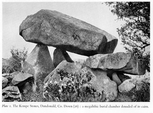
Megalithic Burial Monuments. It was during this agricultural Neolithic Period, which continued for well over a millennium, that the megalithic (or great stone) burial chambers were first erected in Ulster (Plate I). They are the most striking and enduring monuments of the countryside, and have stimulated all manner of story-tellers from that day to this. It is partly because these monuments have attracted so much attention that more is known of burial customs than of living conditions in this age. Many features of the often elaborate design of these monuments were the product of external influences, with roots traceable sometimes even as far as the Mediterranean. There are two main distinctive types of megalithic burial monument to be seen in Ulster -- the 'Horned Cairns' (a variety of Gallery Graves), and the Passage Graves. The Dolmens (or Cromlechs as they were formerly called), consisting of three or four large upright stones supporting a capstone (sometimes as heavy as 20 to 40 tons-see Plate I), are in reality the surviving chambers of these great tombs, the cairns which were originally piled up over them having now wholly disappeared. There are, of course, many other megalithic monuments of simpler design, often betraying in some small detail a relationship with one of the more elaborate groups.
Fig. 1. Ulster Horned Cairns.
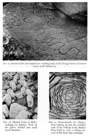
The Ulster 'Horned Cairns', peculiar to the province, are now well-known through the work of Professors Estyn Evans and Oliver Davies. They closely resemble some of the burial monuments across the North Channel and Irish Sea. The forecourt, enclosed between the two 'horns' of the facade, and the segmented burial chambers (PI. 3b), with the long cairn marked out by a border of stones -- the 'peristalith' -- form a striking layout; as at Browndod, Co. Antrim (I) (Fig. I). While in other parts of the British Isles such great monuments were used for collective burials -- like the family vaults of later times -- it is evident that in Ireland they were often intended for single burials, a view supported by the finding at Aghnaglack, Co. Fermanagh (50) (Fig. I), of a complete twin system of forecourts and segmented burial chambers for the burial of two persons under one cairn.
A further distinction of the Ulster 'Horned Cairns' is that cremation was the usual practice, whereas, at this time, in the rest of the British Isles, bodies were not usually cremated before burial. The forecourt seems to have been covered over in the final completion of the cairn, and this layout represents, therefore, a stage in the burial ceremony; the ritual cremation did not however take place within the forecourt itself. Only rarely is the site of the cremation found, as at Doey's Cairn, Dunloy, Co. Antrim (2), where a long cremation chamber was constructed in the cairn behind the segmented chambers. This was also a feature of Yorkshire burial monuments of this period. There are many simplified versions of the horned cairns in Ulster, such as Ticloy, Co. Antrim (3) (Fig. I), continuing the story for many centuries, perhaps well into the succeeding Bronze Age.
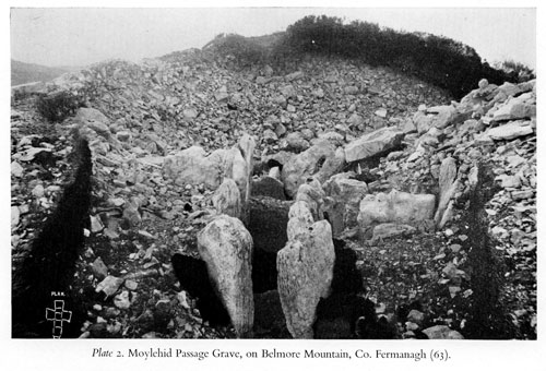
Fig. 2. Passage Graves in Ulster A, Slieve Gullion, Co, Armagh; B, Carnanmore, Co. Antrim; C, Belmore Mountain, Co. Fermanagh, plan of passage and cruciform chamber.
Passage Graves, the other main group of megalithic tombs, are found in north-east and south-east Ulster, but the best known in Ireland are in the Boyne Valley -- New Grange provides an excellent example. The Passage Grave, as its name implies, consists of a straight passage leading to a stone roofed burial chamber, the whole being covered by a round cairn (Fig. 2).
Passage Grave burial chambers are often covered by corbelled vaulting. Plate 3C shows an interesting survival of corbelled vaulting built as late as the eighteenth century. The Ulster Passage Graves exhibit connections with the tombs of Brittany and Spain, and were probably built only a little before the use of metal was introduced into the western seaboard lands. A noteworthy feature of Ulster Passage Graves is the incised or pecked pattern on large upright stones lining the walls of the passage and chambers, as at Knockmany (in State charge) and Sesskilgreen (86) (Fig. 3), both in Co. Tyrone, and occasionally on roofing slabs, as at Carnanmore Co. Antrim (5) (Plate 3a and Fig. 2b). The human remains buried in these tombs seem usually to have been cremated, and the ashes gathered into bags fastened with bone pins. Shallow stone basins as well as numerous smaller objects such as stone beads, pendants, and pots, have been found also in the chambers. The skill with which the vaults were constructed is one of the most remarkable features of these early monuments.
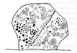
Fig. 3. One of the upright stones which supported the chamber capstone of the Passage Grave at Sesskilgreen, Co. Tyrone, showing characteristic pecked and incised decoration. The stone is about 5 feet high.
The labour required for erection of such massive megalithic burial monuments, often for burial of only a few persons, indicates a well-organised society, and a ruling class commanding the labour or respect of numerous subjects. We are at present, however, only on the threshold of an understanding of Neolithic society. The fact that so much is known already is a testimony to the value of carefully planned excavation, kept up continuously over many years, in studying the life and customs of the peoples of the distant past.
THE BRONZE AGE
The use of metals -- gold and bronze -- was not understood in western Europe until about 2000 B.C., although it had been well-established in the Near East and Mediterranean lands for many centuries earlier. Ireland held an important place in the Early Bronze Age because of her resources of gold and copper; she possessed, however, no resources of tin, an essential element of bronze, and this had to be imported from Cornwall, Brittany or northern Spain. A comparison of the earliest bronze axe-heads found throughout north-west Europe shows that the pioneer Irish bronze-smiths had a ready market in Wales, England and Scotland, and even on the European continent. They seem, however, to have lost much of this trade after a few centuries. A knowledge of metal-work reached Ireland probably by western sea routes rather than across Britain from the east. It may have come in the wake of the Passage Grave tradition, which reached Ireland by a similar sea route, and there is no doubt that in Ireland many of the burial monuments continued in use well into the Early Bronze Age. It is thought that many of the Bronze Age gold articles found in Britain, and in western Europe also, may have had an Irish origin. Certain types or ornament, such as the crescent collars or 'lunulae', are peculiarly Irish, but other types are not found at all in Ireland, and native gold may have been exported, as well as finished ornaments.
The Bronze Age, which extended over some 1,500 years, is subdivided into three periods -- Early, Middle and Late. In the Early Bronze Age, Ireland occupied an important position in the culture of western Europe. Other cultural influences reaching Britain from across the North Sea and English Channel were, however, not felt directly in Ireland, and her influence began to decline although her contacts with Wales and the highland regions of northern England and Scotland always remained strong. The Middle Bronze Age culture grew gradually out of the Early Bronze Age, a change marked by the use of the slender thrusting bronze rapier, gradually supplanting the earlier armoury of bronze and flint daggers. In the Late Bronze Age the rapier was itself outmoded by the heavier slashing leaf-shaped bronze sword, the precursor of and (in Europe) model for the earliest iron swords.
Stone Circles and Standing Stones. The most striking field monuments of the Middle Bronze Age are the Stone Circles. Simple circles of stones abound in most parts of the north of Ireland. In the region of the Sperrin Mountains, in north Tyrone and south Derry, a more elaborate type of stone circle is usual, and can be seen at Beaghmore, Co. Tyrone (in State charge). It consists of two touching circles of small stones, each circle about so feet in diameter, with a cairn at the point of contact, and often with alignments of stones striking off tangentially from the circles. Some of these circles may be ritual enclosures, like the circles of Stonehenge and Avebury on the chalk downs of southern England. Many of the smaller stone circles in Ireland are connected also with burial monument, found sometimes at the centre, such as at Clogherny in the Sperrins (cp. Fig. 4), the 'Druid's Ring' at Ballybrolly (20) near Armagh, and at Ballynoe, Co. Down (in State charge). The mound of the Passage Grave at New Grange on the Boyne, is surrounded by a circle of standing stones. Some circles of smaller stones may be the retaining kerbs of burial cairns, and with the cairn and, perhaps, even the central chamber also, completely removed. Excavations in those areas of England where stone is not pleantiful have revealed that some circles there were made of timber, and similar circles may in time be found in Ireland. Some burial monuments are enclosed by an earthen bank constructed by scraping up surface soil, as at the 'Giant's Ring', near Belfast (in State charge) and not made in the usual manner with material thrown up from a ditch. The 'King's Stables', near Armagh, may have been a monument of this type.
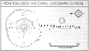
Fig. 4. Plan of tire Stone Circle and Row, and Cairns, at Castledamph, Co. Tyrone.
The isolated standing stones seen in the fields of Ulster are often no more than 'cattle-rubbers', placed there comparatively recently, but occasionally they are of greater antiquity, marking the site of a prehistoric burial, such as those at Punchestown and at Longstone Rath, Co. Kildare, and at Loughbrickland, Co. Down. Burials during much of the Bronze Age were usually under a mound, and often in a stone-lined cist, or small chamber. The remains were usually cremated and the ashes either contained in or covered by a pottery vessel, and it is largely by the character of these vessels that the burials are dated. These pots are known mostly from burials, but evidence is accumulating to show that they were in reality types represented among the domestic pottery of the time. Few habitation sites of this period have been identified in the north of Ireland, but there are some indications of small lightly-built round huts, as at Dundrum, and of more substantial ones at Downpatrick.
The Late Bronze Age, which began in Ireland fairly early in the first millennium B.C., was marked by the introduction of new tools and weapons, such as the slashing sword, and the development of shields in defence against spears and swords. Slashing swords outmoded the slender thrusting rapiers of the Middle Bronze Age. Burials were generally similar to those already described, the funerary pots tending to become larger. The burial cists, often grouped in cemeteries, were not always marked by a mound. A few excavations have revealed details of life towards the end of the Late Bronze Age. Lakeside dwellings and artificial islands (crannogs) were sometimes constructed, and in these a high degree of skill in carpentry appears in the construction of timber buildings, as at Island MacHugh (87), Co. Tyrone, and Ballinderry, Co. Offaly.
THE IRON AGE
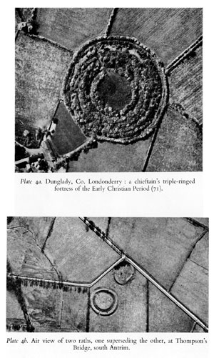
Practically nothing is known about the succeeding Iron Age in Ireland, apart from finds of fine metal-work occurring from time to time on sites which give little clue as to their significance, such as from the bed of the River Bann, and from bogs. These finds, dating from the second century B.C. to the first few centuries A.D., indicate a society in which the overlords had attained considerable wealth, as shown by fine decorative horse-trappings and sword-scabbards. This metalwork represents the material side of hero literature such as the Cuchullain tales, but, although this literary tradition speaks frequently of chariots, there is as yet only a little archaeological evidence of their use in Ireland at that time. Burials probably continued largely in the Bronze Age traditions, and no dwellings have been traced, although some of the sites on the coastal sandhills were occupied during this period. While in Britain this was the age of great hill-top fortresses, in Ireland large earthworks of this type are hardly known here as a class. There are, however, a few enclosures associated with events in early literature, such as Greenan of Aileach, Co. Donegal; Tara, Co. Meath; and Navan Fort, near Armagh (in State charge). Navan Fort is the 'Emania' of the Cuchullain and other tales, the residence of the Kings of Ulster, and supposedly destroyed in A.D. 332. Archaeologically little is known about it, except that three unique bronze brooches of about the first century A.D. were found there and the finest of the Irish Iron Age bronze trumpets came from the lake beside it; in some respects it resembles Tara. The great circular triple-ringed forts, at Lisnagade, Co. Down (30) and Dunglady, Co. Derry (71) (Plate 4a) were used in the succeeding few centuries -- the earlier part of the Early Christian Period -- as chieftains' residences. Recent excavation at Lisnagade and nearby Lisnavarragh (30) has, however, revealed little evidence of any early occupation. The latter two forts lie at the northern end of a long linear earthwork, consisting of a single bank and ditch, known as the 'Danes' Cast' (22), which may be a boundary of this period, similar to the Black Pig's Dyke. The latter is traceable at intervals right across Ireland from Bundoran in the west to Castleblaney on the Armagh-Monaghan border. These earthworks could have been no more than hindrances to cattle raiders, as a vast number of men would have been required to hold their whole length in defence. The Black Pig's Dyke terminates at its eastern end in a great bank and ditch enclosure of 300 acres -- the Dorsey (21) -- which may also have been associated with cattle raiding. It has been suggested that such boundary banks in Ireland were derived from Roman frontier walls or Limes, but they lack one essential feature of such defence systems -- the series of forts and milecastles, or watchtowers, at close intervals along their length. It is now known that such running dykes were already being constructed in Britain in pre-Roman times, and also in Ireland as late as the fifteenth century, like the Pale Ditch. It can only be said that very little is known at present, in spite of excavation, of the date and purpose of the Danes' Cast, the Black Pig's Dyke and the Dorsey.
Ireland and Roman Britain. Although Britain was under Roman rule for nearly four centuries, from A.D. 43 to well within the fifth century, no attempt was ever made (though it was contemplated) to bring Ireland within the Roman Empire. It is customary to consider Roman influence in Ireland as being slight, but contacts across the Irish Sea had been maintained for several thousand years before Britain became a Roman province, and more and more evidence of the influence of craftsmen's methods in Roman Britain on Irish work of that period is becoming apparent. Objects from Roman Britain, particularly metalwork, certainly reached Ireland during the earlier part of the Roman period, probably by trading, and Ireland exported dogs, cattle and hides to Britain. Later, Roman material came to Ireland largely as a result of Irish raiding activities, and a magnificent hoard of late Roman coins and smashed silver dishes from near Coleraine is exhibited in the British Museum. Finally, it should not be forgotten that St. Patrick himself, reputed to have been the son of a Romano-British squire, is said to have been captured in an Irish raid of about A.D. 405-6 either on the Solway Firth or on the south east coast of Wales. It was Romanised Britain, as much as Gaul, which provided the initial impetus for Christianity, the next great cultural influence in Ireland, which has given to Ulster so many remarkable and fine buildings and monuments.
THE EARLY CHRISTIAN AND VIKING AGES
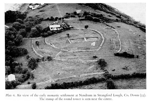
Early Churches. The basis of early Christianity in Celtic lands was the monastic settlement, and several important ones were founded in the north of Ireland. Nothing now survives, except scanty remains of their medieval successors, at the sites of the famous monasteries founded in the sixth century at Bangor and Movilla in Co. Down, and no trace of St. Columba's favourite monastery at Derry can be found. On Nendrum, an island in Strangford Lough, much can be traced of St. Mochaoi's (Mahee) monastery founded in the middle of the fifth century (33) and the remains cover the succeeding seven centuries or so. The air photograph of the site (Plate 6) gives a general impression of the layout of a Celtic monastic settlement, with cells around a small church or oratory, the whole within an enclosure. At Nendrum, it took the form of a 'cashel' laid out in three concentric rings. There is another good monastic site (in State charge) at Devenish on an island in Lough Erne, but the preserved remains are not as early as some at Nendrum.
The earliest buildings used by the founders of the Christian faith in Ireland were probably small oratories and huts of timber or sods. Sometimes, where stone was plentiful, the oratories were built of dry stone, roofed over by a system of corbelling, as at the Oratory of Gallerus, or the huts on Skellig Michael, both Co. Kerry. This method of construction has its roots in the megalithic past when corbelled tomb chambers were the rule, and survived, through the wall and stair chambers of the Irish medieval castles, at least into the eighteenth century (for example the lock-up adjoining the Market House at Newtownards, built in 1770 (Plate 3c)). Even to within living memory this method of construction was used occasionally for small farm buildings. The foundations of one early dry stone built oratory remain at Temple Cormac, Castle Ward, near Strangford (3 I). It stands in a little circular graveyard, but too little survives to show whether or not it had a corbelled roof.
Many of the more important early churches in Ulster are in State charge, such as the fine church at St. John's Point, Ardglass, those at Banagher, Co. Derry, Killeavy, Co. Armagh, and the two small churches side by side at Derry, near Portaferry on the Ards Peninsula, Co. Down, which stand over earlier churches and a still earlier cemetery, and are of masonry bonded with clay, not mortar. Another church of similar construction, much restored, can be seen at Raholp, near Strangford (32). The church in the centre of the monastic enclosure at Nendrum was added to at a later date but this church in its earliest form, together with the southernmost church at Derry, and the church at St. John's Point, all display the feature known as 'antae', a projection of the north and south walls some 18 inches beyond the outer faces of the east and west walls. The presence, originally, of antae can also be traced at Maghera, Co. Derry (in State care). These projections rise at least to the roof line of the gables, and probably supported the roof projection. They can hardly be buttresses, and may be translations into stone of the constructional details of earlier timber churches. Other marked features of these early churches, which cover the period from perhaps the eighth to the eleventh centuries, such as lintelled doorways with inclined jambs, may be seen at St. John's Point, Killeavy, Banagher, and Maghera, Co. Derry. The last named with its fine sculptured lintel and jambs (probably eleventh century), is outstanding.
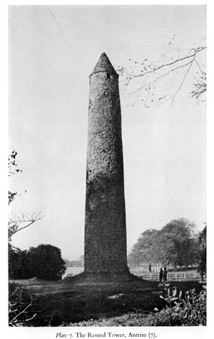
The tall tapering Round Towers, for which Ireland is so famous, are also found on early Christian sites (the only towers of this type outside Ireland are three in Scotland and one in the Isle of Man). There are two complete examples in Ulster -- one at Devenish (in State charge) and the other at Antrim (7) (Plate 7). Each has a conical corbelled stone roof and an entrance raised well above ground level. These towers seem to have been built within the two centuries following the middle of the ninth century, after the first incursions of the Vikings into Ireland, and went out of fashion a little before the Anglo-Norman invasions of the late twelfth century. They appear to have combined the functions of a refuge, a repository for monastic treasures in time of danger, a look-out, and a belfry. Apart from the towers at Devenish and Antrim, stumps may be seen at Armoy, Co. Antrim (8); Nendrum (33) (Plate 6), Drumbo (35), and Maghera, Co. Down (last-named in State charge); and on Ram's Island in Lough Neagh, while a fine one stood almost intact beside the Cathedral at Downpatrick until the I790S.
Crosses. The great standing crosses and memorial slabs are prominent among the remains of early Christianity in Ireland. Only a few slabs survive in the north compared with the large numbers at monastic sites in the south, such as Clonmacnoise on the Shannon. There are a few slabs at Nendrum, and others survive, like that of the early seventh century at Kirkinriola, near Ballymena, Co. Antrim (Fig. 5). Standing crosses were developed in the seventh or eighth century from the earlier decorated pillar stones, of which that with an inscription of about A.D. 700 at Kilnasaggart, Co. Armagh (in State charge) is one of the earliest datable examples. The fine 'Bishop's Stone' at Killadeas, Co. Fermanagh (54) and the simple standing stone, with incised cross in a circle, at Drumconwell, south Armagh, illustrates this class (Fig. 5). The latter has an inscription down the edge in Ogham script, a series of strokes across the edge -- the earliest form of writing known in Ireland, with roots going back into pagan times.
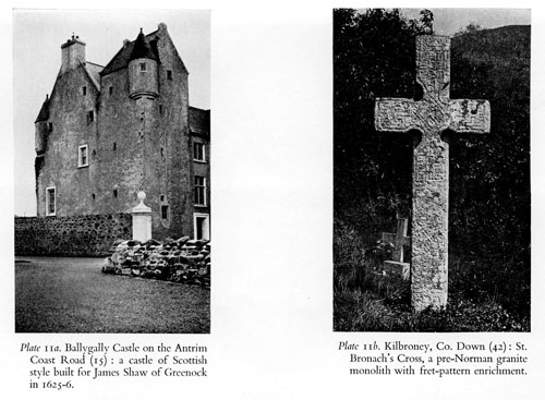
The earliest standing crosses were made in north Britain (Ruthswell and Bewcastle) in the late seventh century. They appeared in Ireland and became more elaborate during the eighth century with a profusion of sculpture, and the wheel head design was developed. The finest eighth century crosses are in the south of the central plain, in Tipperary and Offaly, and the village and island crosses at Tynan (24) (Fig. 5), Co. Armagh (former in State charge) are simple examples of the same type. The full and final development of sculptured high crosses is well seen in the northern group with figure sculpture, of the tenth century, corresponding to the group in mid-Ireland, of which Muiredach's cross at Monasterboice (A.D. 923) is the famous example. The two Ulster crosses at Arboe and Donaghmore, west Tyrone (in State charge) are well preserved; others are to be seen in Co. Down at Donaghmore (36) and Downpatrick, and in Co. Fermanagh at Boho (55) and Galloon. A number of plainer crosses, often with curious and roughly executed decoration, such as those at Kilbroney, Co. Down (Plate 11b) (42) are to be found throughout the Province. It is hardly possible to date these accurately; although most of them belong to this period, some may date from the Middle Ages, when a feeling for the Celtic past remained at times still very much alive in Ulster. By the early eleventh century the crosses with elaborate figure sculpture seem to have fallen out of fashion, although some fine examples bearing mainly ornamental designs, as at Tuam (Co. Galway) may be dated to the early twelfth century.
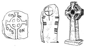
Fig. 5. Early Christian Slabs and Crosses.
Left, slab at Kirkinriola, Co. Antrim, early seventh century; centre, stone with incised cross and circle, and Ogham inscription on the edges, from Drumconwell, Co. Armagh; right, the Island Cross at Tynan, Co. Armagh, probably 8th or 9th century.
Irish native art at this period, more than half a century before the arrival of the Anglo-Normans in 1169, was losing its individuality, as Ireland, under her own church reformers like Malachy, was being brought into conformity within the main cultural stream of western Europe. Nevertheless, Irish sculptors and masons continued to impart a distinctly native character to the Irish Romanesque architecture of the twelfth century, and to the succeeding medieval styles.
Dwellings. In Ireland more is known of the details of everyday life during Early Christian and Viking times than in many other parts of the British Isles; this is largely the result of excavation at carefully selected sites. A methodical examination is proceeding of the sites of what are undoubtedly the dwelling places of ordinary folk, as well as of sites whose importance is recorded in early annals, and thus archaeology and written sources are being combined to give a fuller historical picture of Ulster, archaeology often showing details of everyday life which to the contemporary annalist were too commonplace to be worthy of any comment. It is at this time that most of the Crannogs, or artificial islands, were being built in the lakes of Ulster, though a few were constructed as much as 2,500 years earlier, and many were in use throughout the Middle Ages and into the seventeenth century. Most typical of the dwellings of this period are the 'raths', or 'forts' as they are universally but misleadingly called, which lie as thickly on the Irish countryside as farms and cottages do to-day. In reality they are the farmsteads of more than 1,000 years ago. These 'raths' are small earthworks, circular (or nearly so), with a bank and ditch outside, usually 70 to 150 feet across, and they seem to be of two main types. First, those surrounded by a fairly prominent bank and ditch, forming an enclosure protected at least against marauders and wolves, within which was a small low house, the remainder of the area serving as a farmyard, as shown at Whitefort, Drumaroad, Co. Down, or Ballymacash near Lisburn. This is an Irish version of a type of farmstead in use in many parts of Britain from a few centuries before the Roman period, and some in Ireland might, of course, be as early. The second type is that revealed by Dr. Bersu's full excavation of the rath at Lissue, near Lisburn. The whole area, over 100 feet across, he suggests was roofed over to form one large low circular house, like a great mushroom with no stalk, with the animals and the family living together under the same roof, as they still do in the 'Black Houses' of the Hebrides, and as they did until recently in parts of the west of Ireland. Such excavations reveal the life and economy of these farming communities; wheat was grown, but the emphasis was probably on stock-rearing. They were expert in some crafts, notably carpentry and wood-turning (on a pole lathe), and many beautiful turned wooden bowls have been found on sites of this period. Stave-buckets were also used, and a fine churn (now in the Ulster Museum) made of oak staves and bound with iron came from the ditch at Lissue. In many ways, however, life must have been primitive. Many crannog-dwellers lived a singular life, farming the lands for some distance around their lake, and at this period also a community which ploughed the land, among other activities, was living on the 'Dun' over which Dundrum Castle was built later, as excavations showed in 1950. Raths in some areas were as numerous as ten, twelve or more to the square mile. Traces of three may be seen in the air photograph shown on Plate 4b, 'which covers an area of one sixteenth of a square mile, or 40 acres. At least seven others remain traceable in the square mile surrounding the photographed area. It seems, however, that raths lying close to each other were occupied successively for short periods by three or four generations, and that a fairly large area was farmed from each at a time, though probably not intensively. The small intensively farmed holding is a product of more recent times. Souterrains, or 'caves' as they are called, are another characteristic feature of raths, built within the area or in the thickness of the bank. They were, however, occasionally made independently of raths. They consist of tunnels and chambers, usually stone-lined and roofed, but sometimes of timber, built in deep trenches dug to take them (Fig. 6) (75). They are numerous in Ireland, and are found also in Scotland (earth houses or 'weems'), in Cornwall ('fogous'), and in France, but are unknown in England and Wales. Some have elaborate entrance traps, resembling defensive refuges, while others, with pits (once wicker-lined) dug in their floors, seem hardly defensible and are much more like storage places. A few even bear evidence of having been lived in at times. Probably they combined, in varying degrees, the functions of refuge, hiding, and storage places.

Fig. 6. plan and sections of a Souterrain at Dunalis, Co. Londonderry.
The Viking Age. The life represented by these farmsteads and crannogs continued, with comparatively little disturbance, throughout the period of the Viking incursions, which began at the end of the eighth century. The Norsemen, raiders at first, and later settlers, traders and farmers, founded the first trading towns in Ireland, such as Dublin, Wexford, Waterford and Limerick and, to judge from their names, at Carlingford and Strangford also. But apart from the great cemetery at Islandbridge, Dublin, they have left little trace, the only other sign of their presence being isolated finds, such as swords and spears, and an occasional burial, such as that at Ballyholme, near Bangor, Co. Down, with two tortoise-shaped brooches and a bronze bowl. There is surprisingly little trace of Viking influence in the patterns of the great Irish crosses of the ninth and tenth centuries, though there is more sign of it in the metal work. Styles originating in Scandanavia were more fully established in Ireland in the eleventh and early twelfth centuries than previously, though other similar styles became so general in north west Europe that it is doubtful if Irish patterns can be attributed to more than contact with Scandinavian taste. No forts of Viking raiders have yet been found in Ulster, and in her material culture they remain a shadowy influence. The great Round Towers may, perhaps, be the most permanent memorial to their ruthless raiding, as the founding of our trading towns is to their peaceful settlement.
THE MIDDLE AGES
Churches. Reformers of the Irish Church, like Malachy (born in Armagh in 1095), had been active in bringing it more into the main stream of European tradition, even in the early twelfth century, well before the Anglo-Norman incursions of 1169 onwards. Thus it seems that the Irish themselves did much to temper their own individuality to the prevailing moods of western European culture half a century before Henry II, King of England, with Papal authority, invaded Ireland in 1171 and took the title of Dominus Hiberniae. Malachy became Archbishop in Armagh in 1129, but later he retired to the See of Down, which he formed out of the large Diocese of Connor. He founded houses of the great monastic orders, Augustinian Canons at Bangor in 1137, and at Down, and Cistercians at Mellifont, Co. Meath, in 1142. The regularly planned buildings, as compared with the clusters of cells in the old Celtic monastic settlements, reflect the more strictly regulated way of life of these orders. With the introduction of the Cistercian order at Mellifont in 1142 churches began, for the first time, to be built in Ireland on something more like a continental scale. It was perhaps under Malachy's influence that some semblance of a town, unusual in Ireland apart from the Norse settlements, had grown up at the gate of his Augustinian house at Downpatrick, for John de Courcy found a township in existence there when he came in 1177. A town was also built around the monastic settlement at Armagh. Despite the importance of Ulster in the reform movement, few buildings of this period survive in the province, but at Dungiven Priory (in State charge), an Augustinian Convent is said to have been founded by an O'Cahan chief about A.D. 1100. Some of its detail is comparable with Cormac's Chapel at Cashel, built in 1134. Good work of the twelfth century may also be seen nearby at Banagher (in State charge) and at White Island Church in Lough Erne, Co. Fermanagh (in State charge) where a good Romanesque door has been reset. In the twelfth century also the great crosses ceased to be made, and the latest examples show, as does contemporary metalwork, the assimilation of much that was universal in the decorative art of western Europe at the time. Norman, English, Scandinavian, Rhenish and French influences are evident in work of this period, particularly at Cashel, and by the thirteenth century, after the appearance of Gothic style, Ireland had become a province of Europe. All this progressed under the Irish chiefs, as well as under English influence, and this, and a certain austerity native to the northern province, make it difficult to find in church architecture and sculpture any reflection of what is nevertheless archaeologically most important-that the western part of Ulster remained outside the sphere of English domination until the seventeenth century.
It is unfortunate that destruction and neglect of the sixteenth, seventeenth and later centuries have robbed Ulster of much medieval church architecture which then existed. In the late twelfth and thirteenth centuries, under Anglo-Norman influence, new houses of the great orders were founded in Co. Down. At Downpatrick in 1183 John de Courcy replaced Malachy's Augustinians by Benedictine monks from St. Werbergh's, Chester, and their medieval church stood, with a tall round tower of earlier days beside it, until its ruin was rebuilt in the I790S, and must have looked as impressive as the rock of Cashel. Considerable remains of two fine Cistercian abbeys (both in State charge) are to be seen at Inch, near Downpatrick, founded in 1180, a daughter house of Furness Abbey, Lancashire, and at Grey Abbey, on the Ards Peninsula, founded in 1193, a daughter house of Holm Cultram, Cumberland. At Armagh the main lines of the present Protestant Cathedral follow the church of the later thirteenth century, but the extensive restoration in 1834 has robbed this once fine and important church, seat of the Primate of all Ireland, of its authentic medieval character. Of parish church architecture of the thirteenth and fourteenth centuries, the most interesting remains are at St. Nicholas' church, Carrickfergus, Co. Antrim. Most parish churches in Ulster tended to be small and plain buildings, as at Cranfield, Co. Antrim; Ardtole, Co. Down; and Aghalurcher, Co. Fermanagh -- all in State charge -- and Ringhaddy, Co. Down (44).
Little church architecture attributable to the fourteenth century can be found in the north of Ireland; the same is largely true of Scotland, for this was a century when English ascendancy had waned and the struggles, from which a new and more native culture arose, were still in progress. In the fifteenth century an individual character once again appeared in Ulster church architecture, probably attributable to a religious revival under the native princes. Windows, though small, often contain good tracery. Some of the main features of the English 'Perpendicular' style, such as long mullions rising through the full height and joined horizontally by transomes (an achievement of the English master-masons in the fourteenth and fifteenth centuries), may be found in combination with swirling curvilinear tracery patterns. This curvilinear tracery, though developed in England during the early fourteenth century, soon went out of fashion there, but was adopted on the continent, especially in France, where it became the basis of the 'Flamboyant' style, and its appearance in Scotland in the fifteenth century is due to French influence. The appearance of this flowing style in Ireland also at this time is probably due to Scottish as well as direct continental influences.
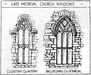
Fig. 7 Later medieval window tracery in Ulster Churches: (a) left, Culfeitrin, Co. Antrim, east window; (b) right, Balleeghan, Co. Donegal, east window.
Fig. 7a shows the fine east window of Culfeitrin parish church, north-east Antrim, which reflects the English perpendicular style. Fig. 7b shows the combination of English 'perpendicular' transom and flamboyant tracery at Balleeghan, Co. Donegal. At Dungiven Priory, Co. Derry, as also at Sligo Abbey, is a traceried tomb-recess with effigy, of Irish type, but betraying again some continental influence. Hood-mould stops were often carved with foliage (Fig. 7a), which developed in later times into a revival of old interlace patterns of pre-Norman days. This revival of interlace is also seen in the fifteenth or sixteenth century slab and cross at Devenish (in State charge), as well as the Mac Swyne grave-slab of the mid-sixteenth century at Doe Castle, on Lough Swilly, Co. Donegal, and the window spandrels of the Mint at Carlingford.
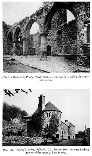
Some good towers may also be dated to the fifteenth century, such as at the ruined church at Magheralin, Co. Down (1442). The central towers inserted into the Friary churches in the fifteenth century, which look like castles with their crow-stepped battlementing, are a familiar feature further south, but are not in evidence in Ulster. The Friary at Carrickfergus had a spire (Plate 12), and the tower of the Dominican Friary in Newtownards (where there is also much seventeenth century work) (Plate 13a), resembles the style of Magheralin. Layde church, Cushendall, Co. Antrim (13) (Fig. 8) had a tower with a stone vault over the ground floor chamber, added probably in the fifteenth century, to protect priest and valuables alike from fire. Another vault of this type appears to have been built in 1447 at Aghalurcher, Co. Fermanagh (in State charge). The tradition of Gothic style, though often with renaissance detail, was continued in Ulster in the sixteenth and seventeenth centuries by the English planters.
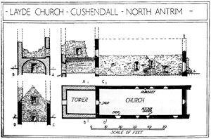
Fig. 8. Ground plan and sections of the medieval Church at Layde, near Cushendall, Co. Antrim. The vaulted tower was built on to the Church.
Castles. The Anglo-Norman invasion of Ireland, which started in 1169, may be said to have introduced the medieval type of castle.
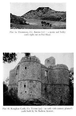
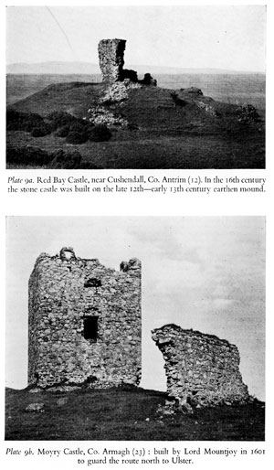
The Annals record that a few 'castles' were erected by Irish princes earlier in the twelfth century, but no certain remains of these can at present be traced. The earliest castles were of the mound and bailey type, an earthen mound or motte, having 'a palisade and sometimes a timber tower on top,' with the adjoining courtyard defended by a ditch and palisaded bank. Not infrequently in Ireland, and sometime also in Scotland and Wales, the bailey was omitted, giving a simple mound such as may be seen in eastern Ulster at Dundermot and Dungall, Co. Antrim and Dundonald, Co. Down (38). In the Irish territory to the west of Lough Neagh large motte-like mounds are rare, but may be seen for instance on a tongue of land jutting into Lough Fea (84) in the Sperrin foothills, here perhaps the work of an O'Neill of Tyrone. Fine examples of the motte and bailey type are seen at Clough (41), Ballyroney (39) and Dromore, Co. Down (the last-named in State charge), and at Harryville, near Ballymena, Co. Antrim (10). These Norman mounds or mottes are recognisable by their characteristic shape, a truncated cone (Plate 8a). Stone buildings, such as a tower, hall or shell-keep, were sometimes built subsequently on the summit of the mound, as at Clough, Co. Down (41), excavated in 1951, and Red Bay Castle, Co. Antrim (12) (Plate 9a). This earthwork and timber type of castle had already gone out of fashion in England at about the time they began to be erected in Ireland. They continued to be built and used in Ireland (and sometimes in Wales and Scotland) from the late 1160s onwards well into the thirteenth century. Some were still in use even in the fourteenth and fifteenth centuries.
Even before the end of the twelfth century, however, the construction of great stone fortresses had commenced in Ireland, and their designs did not fall much behind those developed at this time by the military engineers of the English Crown. In Ulster, Jolm de Courcy's private invasion of 1177-85 was evidently followed up rapidly by the erection of stone curtain walls at his castles of Dundrum Co. Down and Carrickfergus (in State charge), and the massive stone keep of the latter followed soon after. These castles were extended and greatly strengthened early in the thirteenth century. At Dundrum a great circular keep was constructed like that at Pembroke and other castles in south Wales, and at Carrickfergus and Dundrum the tall, double-towered gatehouses were erected. Further stone castles were built in the north of Ireland at this time, at Carlingford and Castleroche, Co. Louth, and, about the middle of the century, at Greencastle, Co. Down (in State charge), Coleraine (now completely destroyed), and at Dunluce, Co. Antrim (in State charge). At Greencastle, Inishowen, Co. Donegal, there is an impressive stronghold, built in the main probably by Richard de Burgh, Earl of Ulster, about 1300. These were the great stone fortresses of the English Crown and its vassal lords and must be largely works of English military engineers on Irish soil. They should accordingly be treated as such, and be interpreted in terms of their contemporaries in England and Wales, as part of the main stream of western European tradition.
During the fourteenth century Anglo-Norman power in Ireland weakened, and large stone garrison castles were no longer built. Carrickfergus alone of these fortresses in the north has a continuous recorded history as an English garrison. The Irish princes themselves, however, were not inactive in castle building in the fourteenth century, and the work of their engineers and masons, based on the English models, may be seen at Harry Avery's Castle, Co. Tyrone (in State charge) and Elagh, near Londonderry City. Western Ulster is of great interest as a region which lay almost entirely outside Anglo-Norman influence all through the Middle Ages, until after the flight of Hugh O'Neill in 1607.
Tower-houses. Irish native building of the fourteenth century probably paved the way for the development and popularity of the tower-house in Ireland during the fifteenth and sixteenth centuries. The tower castle was developed in Scotland and in parts of England during the fourteenth century, and the Irish tower-houses were probably a parallel though somewhat later development stimulated by similar conditions. In native west Ulster, Harry Avery's Castle, though it looks like a gatehouse is in function really a tower residence, built probably in the later fourteenth century. From the 1420s, tower-houses were being built more generally in Ireland as landowners' residences, and in 1429 a £10 subsidy was granted to any land-holder who would build a tower of 20 feet by 16 feet and at least 40 feet high to strengthen the defence of the English Pale. Kilclief, Co. Down (in State charge) was built between 1412 and 1441 and may well have been the prototype of the County Down tower-houses with projecting front towers, joined by an arch high up, reminiscent of the appearance of the thirteenth and early fourteenth century gatehouses and the gatehouse-keeps of the later Middle Ages. This type is also illustrated by Audley's Castle, near Strangford (in State charge) (Fig. 9). The latter had a small courtyard, or 'Barmkin' attached, to be seen originally beside other tower-houses, though in many cases now destroyed. The main features of these tower-houses are a stone vault over the ground or first floor, as a protection against fire, with the main chamber above (Fig. 9), and a stair either in a projecting tower or within the thickness of a wall. The entrance at ground floor level is defended either by an external machicolation, as at Castle Ward, (48) (Fig. 16) and Strangford, Co. Down, (in State charge) or by internal 'murder-holes' just above the inside of the door, as at Nendrum, Co. Down (45) (Fig. 9) and at Walshestown, Co. Down (47) (Fig. 9). The external profile is distinguished sometimes by a graceful batter, and by the crow-stepped battlementing so typical of these castles.
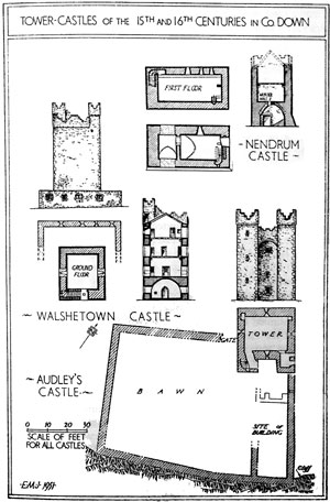
Fig. 9. Plans, elevations and sections of late medieval (Nendrum and Audley's) and 16th century (Walshestown) tower castles in Co. Down.
This type of tower castle continued to be built throughout the sixteenth century, and surviving remains are common in Co. Down, as at Walshestown (47), Castle Ward (48), and Narrow Water (in State charge), and elsewhere in Ulster also, as at the Curran (or Olderfleet) at Larne (early sixteenth century-in State charge) and Castle Chichester at Whitehead (built in 1604). In the west, the tower on Island MacHugh, Baronscourt, Co. Tyrone (87) had already been built by 143 I, though remains of this type are rarer in western Ulster, possibly due partly to destruction. The stones of Shane O'Neill's sixteenth century castle of Benburb were taken for the building of the English fort at Blackwatertown in 1595. The tower castles continued to be built in the seventeenth century, as at Kirkistown on the Ards peninsula (built in 1618), with its bawn wall and flanker towers still largely intact. At Derryhivenny, in Co. Galway, a tower castle of this kind with bawn and flanker towers was erected as late as 1643, and in Scotland tower castles were being built occasionally as late as 1660.
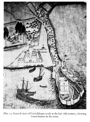
Tower-houses were not confined to the countryside, but were also built close together in towns. Plate 12 shows a view of Carrickfergus about 1580, and gives an excellent impression of an Ulster township of this period. The present Town Walls (17), which replaced an earlier bank and ditch, are shown almost completed, except where the Friars' Church still stood at the north-east. This was cleared away early in the seventeenth century for Sir Arthur Chichester's fine house, Joymount, itself now completely destroyed. The tower-houses are shown interspersed among squat thatched cabins. No tower-houses are now left at Carrickfergus, but a good example of the later sixteenth century is preserved at Strangford and there are several at Carlingford. At Bangor, Co. Down, there survives on the water front a tower and house of strong Scottish character with corbelled stair and crow-stepped gable, which was still under construction in 1637, and intended as a customs house (49) (Fig. 10). The small town of Ardglass (46) possesses several fifteenth century examples of these town tower-houses-Jordan's Castle (in State charge), Margaret's and Cowd Castles and the 'New Work' -- a row of merchants' stores down by the water. Until a century ago several more survived. There are no earlier remains in Ulster of town life. The 'Ports of Ulster', as they appear in the Customs Rolls of the fourteenth century, were Dundalk, Carlingford, Strangford, Carrickfergus and Coleraine, and town life seems to have made no appeal to the Ulster Irish away from the coastal areas of Down and Antrim.
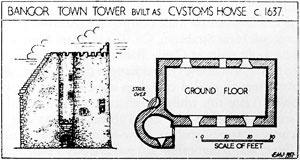
Fig. 10. Ground plan and east elevation of the town tower at Bangor, Co. Down, of strong Scottish character.
THE PLANTATION PERIOD
Planters' Castles. With the flight of Hugh O'Neill, Earl of Tyrone, and the Earl of Tyrconnell in 1607, Ulster, which throughout the Middle Ages had been an almost untouched stronghold of Irish native culture, was suddenly thrown open to Scottish and English settlers. Planted among a more or less hostile population, these settlers required fortified residences, and a type of 'strong house and bawn' was developed to meet their needs. There is a marked vein of Scottish influence running through them, for the construction of fortified residences was still a vigourous tradition in Scotland at that time, although they had long ceased to be built in England. There are some specific details which indicate the presence of skilled Scottish craftsmen in Ulster. Most striking are the round turrets with conical roofs, some corbelled out high up on the angles of the towers. They are to be seen in their original state at Ballygally (15) (Plate 11a), which is really a Scottish castle built on the Antrim coast for James Shaw of Greenock in 1625-6. This corbelling-out, a style of continental origin in the Middle Ages, was highly favoured by Scottish masons in the sixteenth and seventeenth centuries, and they covered their work with a profusion of variants on this theme, hundreds of examples surviving in Scotland. In Ulster, the ten extant examples of this style of moulded coursed corbelling display the whole range of the theme; at least two more are known to have existed, and this particular Scottish characteristic is not found in Ireland outside Ulster.
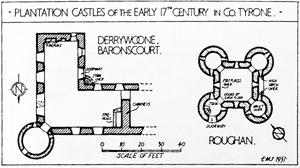
Fig. 11. Ground plans of Scottish Planters' Castles, or Strong Houses, in Co. Tyrone.
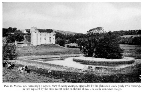
Round angle-turrets occur at Ballygally (15) (Plate 11a) and Dunluce (in State charge), Co. Antrim; Aughentaine, and Mountcastle (near Strabane), Co. Tyrone; and Monea (Plate 10); and corbelled-out stairs at Castle Balfour, Co. Fermanagh; Derrywoone (90); Aughentaine (95); and Bangor (49) (Fig. 10). At Monea, square crow-stepped gabled chambers are corbelled out to cap the round towers (Plate 10), while a high arch with corbelled springers is to be seen at Roughan (92) Co. Tyrone, (Fig. 11 and Plate 8b). Other Scottish features, such as crow-stepped gables, can often be seen in Ulster, as at Bangor (Fig. 10) and Dalway's Bawn, at Bellahill near Carrickfergus (16) (not visible in Plate 13b) and Newtownstewart, Co. Tyrone (93). One example of corbelled' turrets, the fine Water Gate at Enniskillen (59) (Fig. 17), is not so particularly Scottish, for examples of coursed corbelling used thus may sometimes be seen on medieval gatehouses in England and Wales -- Lewes, Sussex; Micklegate, Bootham and Monk Bars at York; and Harlech and Beaumaris Castles in North Wales. This Water Gate seems to be in fact a little earlier than the Plantation, as it appears in a pictorial map of 1593, though not in one of c.1570-80. It would, therefore, appear to have been built in pre-Plantation days when Enniskillen Castle was still a Maguire stronghold. The town was not founded until the early seventeenth century. It is significant that such a Water Gate should have been built for an Irish chief in the turmoil of that age.
Many of the defended houses and bawns built for English settlers do not show this specific Scottish character, though even then other Scottish details may sometimes appear, such as the crow-stepped gables at Dalway's Bawn (16) (Plate 13b), which is a typical bawn with corner towers, or 'flankers', built in 1609. A tradition of castle building was still very much alive in Scotland at that time, whereas it had largely finished in England more than a century earlier. The English settlers, therefore, had to draw their ideas on fortifying their residences from the Scots or Irish, or else extemporise: they seem to have done all three. The strong houses and bawns built for the London City Companies on lands granted to them by the Crown in 1613, in County Londonderry, are illustrative of other buildings erected for English settlers, who must have regarded themselves as colonists not so very different from those who crossed the Atlantic at this period. Plans of the 'castles' of the Skinners' Company at Brackfield (80) and of the Salters' Company at Salterstown (81), both in Co. Derry, are shown in Fig. 12, with inset views taken from the pictorial maps made for Sir Thomas Phillips in 1622. The bawn and flanker towers of 1622 may still be traced, but in each case the houses of that time appear to have been smaller than those revealed by examination of the surviving structures. The walls and flankers contained many pistol loops. It is, perhaps, surprising that a standard pattern had not been devised for the 'castles' of the London Companies, but, in fact, no two of the other known examples appear to have been even so much alike as Salters town and Brackfield. The 1622 views show these 'castles' set in the midst of the Plantation townships, with English style timber-framed houses, and thatched houses and cabins. The final stages of the defended house in the north of Ireland are represented by the White House, near Cloghy, Co. Down, where an English-type seventeenth century yeoman's house is fitted with pistol loops, and surrounded by a bawn wall with a gatehouse but without flanker towers at the corners.
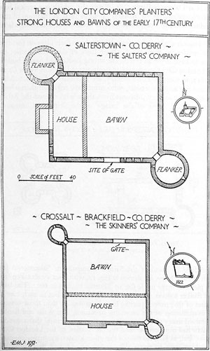
Fig. 12. Ground plans of Strong Houses and Bawns of the London City Companies in Co. Londonderry. The views inset in the north points are taken from Sir Thomas Philips' Survey of 1622.
Military Forts. The forts erected by military commanders during the numerous campaigns of the later sixteenth and early seventeenth centuries may be illustrated by those built for Lord Mountjoy, the Lord Deputy, during his campaign of 1600-2 in the North.
Moyry (23), built to secure the pass into the north from Dundalk to Newry, is known to have been erected under the supervision of a Dutch engineer, though it shows no sign of such a designer. It consists merely of a simple rectangular enclosure and small square tower (Fig. 13 and Plate 9b). Mountjoy itself (in State charge) was
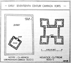
Fig. 13. Early 17th century forts in Ulster: Moyry, a real campaigning fort of 1600-2; Mountjoy, the surviving stone and brick house of 1605 built within the now disappeared earthen campaign fort of 1601-2.
next built on the western shore of Lough Neagh, and there now survives here a strong brick tower on stone footings which was completed in 1605 (Fig. 13). Charlemont Fort (25), on the Armagh-Tyrone border near Moy, is a third example, where the whole castle, as completed by 1624, survived until 1921 when the main tower was burnt and then demolished (Fig. 14). The outline of the surrounding earthwork with spear-shaped corner bastions can still be seen, the outer banks with the mid-wall bastions being put up probably in 1673 (Fig. 15). A surrounding earthwork originally existed at Mountjoy, as recorded in contemporary descriptions, and in 1602 the garrison of this fort consisted of 100 horse and 1,100 foot, far beyond the capacity of the surviving stone and brick building. The remains at, and old views of, Charlemont and Mountjoy forts, taken in conjunction, give a good idea of a fort built to house a garrison at this period, and Moyry is probably a real campaigning fort. Judging from contemporary maps, there were in the Irish countryside at this time many small, star-shaped earthen forts such as that built in 1689 on Fort Hill, Enniskillen, and still well-preserved. Few can be traced to-day, but more would probably be revealed by systematic air-photography. Mount Norris, 8 miles north-west of Newry, another fort of Mountjoy's campaign was, according to an eye-witness, erected in 6 days in November, 1600. It was later described as well ramparted with sods but it has not yet been traced -- even from the air. At Hillsborough, Co. Down, is a large fort of 1641, (in State charge) with earthen banks later consolidated with a vertical stone exterior facing, spear-shaped corner bastions, and (in the mid-eighteenth century) a 'gatehouse' tower with angle projections which incorporates the original gatehouse.
The development of arrow and gun slits may be followed in the castles here described. At Greencastle, Co. Down, (in State charge) can be seen the remains of long narrow slits, of the thirteenth century, backed by large recesses for archers. The same feature is preserved at Harry Avery's Castle (fourteenth century) near Newtownstewart (in State charge). By the mid-fifteenth century, the slits and recesses were much smaller, and must have been intended mainly for early hand-guns. Guns are not mentioned in accounts of Irish warfare until the 1480s, but they must have been used much earlier as they had been in use in England from the early fourteenth century. These early slits have a double splay which gives a good traverse for the gun, as seen at Audley's Castle (in State charge) (Fig. 9) and many other examples, but the double splay seems to have gone out of use during the sixteenth century, as it was found that shots fired at the castle could ricochet off the outer splay and enter the building through the slit. Later sixteenth century slits are therefore splayed only on the inside, as at Walshestown (47) (Fig. 9). By the later sixteenth century the musket or pistol loop had been developed, with a small outer hole rather than a slit, such as may be seen at Moyry Castle (23) (Fig. 13), and at many other places.
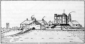
Fig. 14. A view of Charlemont Fort in 1850, showing the central tower-house (built in 1620-4) (compare Mountjoy), and the solid banks for Artillery defence.
Artillery Fortifications. Little attempt seems to have been made in Ireland in the sixteenth century to build a permanent coastal fortifications designed for use with, and defence against, artillery comparable with, say, St. Mawes and Pendennis, of the 1540s, in Cornwall. This is perhaps surprising in view of the strategic position of Ireland in England's struggle with Spain. In the North, cannon ports of the mid-sixteenth century may be seen at Carrickfergus (in State charge), where also about that time the gatehouse towers were lowered to their present squat shape and the battlementing fitted with new embrasures for cannon.
The type of low fort with spear-shaped pointed bastions was developed in Italy in answer to the needs of artillery warfare during the earlier part of the sixteenth century, and had begun to be used in England by the mid-century, as at Berwick. Paul Ivey's work of 1593 at Pendennis is a good surviving example. Old pictorial maps suggest that this type of fortification was also being constructed in Ireland by the late sixteenth century (Plate 12); such a plan may still be seen in the lay-out of the walls of Londonderry (1613-1618), and Charlemont (25) (Fig. 15) in the outline of the inner earthworks by 1624. A view of Charlemont Fort in 1850 (Fig. 14) shows this low massive earthen outer bank, ideal for defence against artillery. This type of glacis may still be seen at Castle Rushen in the Isle of Man. Charlemont Fort did not achieve its final appearance until the 1670s, and the plans of the outer works there is comparable with the Civil War artillery earthworks in England, with every part of the perimeter coverable by flanking fire from cannon and muskets in the bastions.
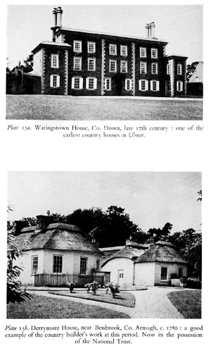
The age of castelled architecture in the north of Ireland had ceased by the latter half of the seventeenth century, and defended farmhouses with pistol loops, like the White House, near Cloghy, represent the final stage. Considering how disturbed conditions remained in Ireland, Irish houses, unlike some in Scotland, show surprisingly little provision for defence from the middle of the seventeenth century onwards. The purely domestic style of the later seventeenth and early eighteenth centuries is seen in Waringstown House, Co. Down (late 17th cent.) (Plate 15a); Richhill Castle, Co. Armagh (built c. 1660); and in town houses, e.g. those with shaped gables, formerly in Boat Street, Newry.
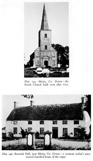
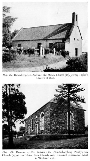
Later Houses and Civic Buildings. No detailed discussion of domestic architecture can be attempted here, but a few examples will illustrate the mood of the Georgian tradition in Ulster, for some individual aspects of which the term 'Ulster Colonial' has been aptly used. For their churches the seventeenth century English settlers employed a survival of Gothic style as at Waringstown, Co. Down; and in the eighteenth century an individual combination of Gothic structure and Renaissance detail was developed from this, illustrated by Moira Parish Church, Co. Down (Plate 14a), with its spire set immediately above a well-designed classical doorway. This Gothic survival is a general undercurrent in English church architecture of the renaissance, and the influence of James Gibbs (I682-1754) was widely felt, especially in his detail (compare the broken architraves in Plate 16b), and his design of St. Martin's-in-the-Fields (1722-6) provided a pattern for over a century (First Bangor Presbyterian Church, 1831), extending even to America. He produced his Book of Architecture (1728) for those concerned in building 'in the remote parts of the country where little or no assistance for Designs can be procured.' During this period, largely due to the Scottish settlers, the 'Meeting House' or 'Barn' type of church was in common use in Ulster (Plate 16b), and by the late eighteenth and early nineteenth centuries had developed the imposing and well-designed classical facades which are a prominent feature of Ulster country towns.
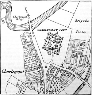
Fig. 15. Charlemont Fort, as represented on the first Ordnance Survey 6 inch to one mile map, of 1832, showing the outer defences added in 1673 to the star-shaped fort completed by 1624·
Among the earlier domestic structures which still remain, the yeomen's two-storied thatched houses are of great interest. Such houses are common enough in townships in most parts of Ireland, but isolated yeomen's houses in the countryside are generally found in regions which were colonised predominantly by the English settlers, such as north-west Down and adjacent parts of Antrim, and Armagh. They are not to be seen in areas settled by the Scots, such as east Down and Antrim. Some, like the yeoman's house at Waringstown, or Berwick Hall near Moira (Plate 14b) may be dated to the later years of the seventeenth century. The same type was still being built in the later eighteenth and early nineteenth centuries as at Ballinderry and Aghalee, Co. Antrim.
Derrymore House, near Bessbrook, Co. Armagh (Plate 15b), shows an unusual combination of a group of low thatched-roofed buildings with a more ambitiously conceived entrance. It has a patterned oval fanlight over the door which is so universal and pleasing a feature of Irish houses of the later eighteenth and early nineteenth centuries. It was built about 1780, and is where, reputedly, the Act of Union was drawn up in 1799. The Steeple House, beside Antrim Round Tower, is an example of a larger house, with its low pitched roof, expansive overhanging eaves, broad bow windows and corner pilasters, epitomising the Ulster country house of the early Victorian period. The Regency style persisted late in Ulster, where the Gothic Revival was only lightly felt, and Steeple House might be as late as 1840. Such good houses of the eighteenth and earlier nineteenth centuries, both small and large, are abundant in the Ulster countryside. They often lie unobtrusively away from the main roads, but are well worth seeking out.
Ulster possesses many country mansions some of which are known to have been designed by well-known English and Irish architects of the front rank. Of the English architects, James Wyatt's Castle Coole, Co. Fermanagh (1788), for which large quantities of Portland Stone were imported through Ballyshannon; Sir John Soane's designs at Baronscourt, Tyrone, and the Royal Belfast Academical Institution (1810); and John Nash's rectory at Lissan, on the Derry-Tyrone border, and his loggias at Caledon, are outstanding. Thomas Cooley (who came from England, in spite of his Irish-sounding name) designed the central core of Caledon House (built in 1779), and the Primate's Palace at Armagh (built c. 1770). Buildings which can be definitely attributed to well-known Irish architects are rare in Ulster, but the work of Francis Johnston merits particular mention for his creation of much of the attractive late Georgian character of Armagh. The most important of these buildings are the Observatory (1789--90) and the Court House (1809). Much of his work at Armagh, and of the work strongly influenced by him, was carried out in beautiful limestone from Armagh quarries, which resembles Portland stone in its whiteness but gives a more varied finish. These buildings, and others like Hillsborough Court House of the later eighteenth century and many in Newry, of fine grey or pinkish Mourne granites, show how much opportunity has been missed in Ulster when other than local materials have been used for mansions and important buildings.
It is fitting to close this survey with some mention of civic architecture in the province. Town plans, even as far back as the early seventeenth century, have a late eighteenth century deliberation about them, an element no doubt of the Plantation, as may be seen at Londonderry, Coleraine and Killyleagh, Co. Down. Town Halls and Court Houses were developed during the eighteenth century in a simple, well-proportioned classical style, as may be seen in many Ulster townships. The tradition, like that of classical facades on Meeting Houses, persisted late, well into the nineteenth century, the Courthouse at Newry having been built as late as 1843. The large Market House at Newtownards (1765) was designed by Ferdinando Stratford, a Bristol water-engineer, whose drawings for it survive; its corbel-vaulted lock-up (Plate 3c) shows the native builders at work. The Court House at Hillsborough of the late eighteenth century (in State charge) (the designer of which is unknown although the original plan survives) is a pleasing combination of the textures of local materials, with its lower courses of beautifully textured granite from the Mournes, 25 miles away, its middle courses of Scrabo sandstone and its harled and colour-washed tower. It is an excellent example of a style of civic architecture which, with its classical frontages and pleasing cupolas, is to be found in many Ulster townships, emphasising in a most refreshing manner the individual character of the Province.
ANNOTATED LIST OF MONUMENTS
COUNTY ANTRIM | |
| 1. BROWNDOD HORNED CAIRN. | A few yards from the summit of Browndod Hill, about 6 miles to the north west of Antrim. |
| A well preserved long cairn with four aligned chambers and a 'horned' facade. The chambers and the forecourt are in a good state of preservation, and the peristalith of the long cairn itself can be traced in several places (Fig. 1). | |
| 2.DOEY'S CAIRN. | Three-quarters of a mile south east of Dunloy, a village about six miles to the south of Ballymoney. |
| An unusual horned cairn, oval in shape, with a single megalithic chamber. An excavation in 1935 yielded two finely polished axes, and revealed a long cremation pit within the cairn behind the burial chamber. | |
| 3. TICLOY HORNED CAIRN. | One-quarter of a mile south of the summit of Ticloy Hill, about 8 miles to the north east of Ballymena. |
| A single-chambered megalithic grave, which once had a long cairn extending back from the chamber. Traces of its horned cairn ancestry are to be seen in the shallow forecourt (Fig. 1). | |
| 4. DUNTEIGE 'GIANT'S GRAVE'. | One-quarter of a mile east north east of Dunteige Bridge, about five miles to the north west of Larne. |
| An unsegmented gallery grave, included as an example of the 'wedge-shaped' class. | |
| 5. CARNANMORE PASSAGE GRAVE. | One and a half miles to the south west of Torr Head. |
| A fine passage grave in reasonable state of preservation, with a corbelled chamber, in the sloping roof of which is incorporated a decorated stone with pocked rings, 'serpent', and cupmarkings. (Fig. 2b and Plate 3a). | |
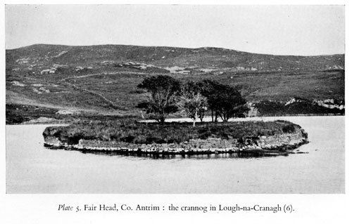
| 6. FAIR HEAD CRANNOG. | In Lough na Cranagh, about 2 miles to the east of Ballycastle. |
| The crannog is oval in shape, approximately 120 feet by 90 feet, and is faced towards the lake by a dry-built revetment rising to over five feet above water level. It is fairly well preserved (Plate 5). | |
| 7. ANTRIM ROUND TOWER. | In an estate about one mile to the north of Antrim. |
| This tower, 93 feet high and almost 17 feet diameter at the base, and that at Devenish (Lough Erne), are the most perfect and largest round towers in Northern Ireland (Plate 7). Near the tower in a natural rock is a fine bullaun, one of the oldest relics of Christianity in Ireland. It is generally believed that these font-like basins were of pre-Christian origin, and were adopted by the early Christians as fonts or repositories for holy water. | |
| 8. ARMOY ROUND TOWER. | In the village of Armoy, about 6 miles to the south of Ballycastle. |
| The round tower dates back to the tenth century when Viking raids were frequent. The door -- 5 ft. 9 in. high and only 19 in. wide -- is said to be the narrowest round tower door in Ireland. The adjacent modern parish church is on the site of a church built here about the year 460 by Olcan, who was a disciple of St. Patrick and was consecrated a bishop by him. |
|
| 9. KNOCKAHOLET MOTTE. | About 6 miles to the south of Armoy, and 6 miles to the east of Ballymoney. |
| The motte has a ditch round it, and lies centrally within an oval earthwork, giving a small bailey at either end. | |
| 10. HARRYVILLE MOTTE. | On a ridge in the southern suburbs of Ballymena, overlooking the River Braid. |
| Harryville is one of the best examples in Northern Ireland of the feudal motte and bailey castles of the early Anglo-Norman period. The motte is circular, about 140 feet in diameter at the base, rising 40 feet in height to 40 feet diameter at the top. The bailey is almost rectangular in shape. | |
| 11. DOONMORE MOUND. | Two miles to the east of Ballycastle, and less than half a mile westward of Lough na Cranagh. |
| A typical motte and bailey carved out of a natural outcrop of basalt probably by an early Anglo-Norman settler (c. 1180). The whole is oval in plan, and was originally surrounded by substantial stone walls -- 3 to 4 feet thick -- of which little more than the foundations now remain (Plate 8a). Excavated by Prof. V. G. Childe in 1937· | |
| 12. RED BAY CASTLE. | On a natural promontory about 1 mile to the south of Cushendall on the Antrim Coast Road |
| The stone castle built on top of the motte is probably sixteenth century work, and is attributed to Sorley Boy O'Donnell. It was finally destroyed by the Cromwellian garrison of Carrickfergus about 1652. The largest fragments now remaining are part of a tower with finely moulded string course, and portions of the bawn wall of much rougher construction. (Plate 9a). | |
| 13. LAYDE CHURCH. | About 1 mile to the north east of Cushendall. |
| First mention of this church is made in the Taxation Roll of c.1300, and many of the remaining features suggest that it may be quite as old as this. Layde Church was in use up to 1790 when it was replaced as a parish church by a temporary building in Cushendall. (The present parish church was built in 1832) (Fig. 8). | |
| 14. DUNSEVERICK CASTLE. | One and a half miles to the west of White Park Bay, 7 miles from Ballycastle. |
| This impressive site, stormed by the Vikings in 870 and again in 924, passed into the possession of the O'Cahan family about the 16th century (perhaps earlier), and was held by them until the execution in 1653 of Gilladuff -- the last O'Cahan of Drinseverick -- who was deeply implicated in the 1641 Rebellion. The remains appear to be those of a gatehouse -- probably of the sixteenth century. Destruction of the castle is attributed to Cromwellian troops. Presented to the National Trust in 1961. | |
| 15. BALLYGALLY CASTLE. | In the village of Ballygalley on the Antrim Coast Road, mid-way between Larne and Glenarm, and about 5 miles from each. |
| The castle, erected for James Shaw of Greenock in 1625 is probably the best example in Northern Ireland of a Scottish baronial castle of that period, and is in very good state of preservation. The castle has been incorporated in a hotel, the modern architecture harmonising with the seventeenth century features, which have been carefully respected (Plate 11a). |
|
| 16. DALWAY'S BAWN. | About 3 miles to the north east of Carrickfergus on the Bellahill road. |
| This is probably the best preserved of the 'Bawns and Flanker-Towers' of the early seventeenth century still existing in Northern Ireland. The rectangular enclosure with three round corner towers (two of which are in use) was probably built in 1609 by John Dallowaye, who received a royal grant of lands in this vicinity in 1606. There was apparently never a tower at the fourth corner. On the road front over the arched gateway between the towers is a ring said to have been used formerly as a gallows (Plate 13b). | |
| 17. CARRICKFERGUS TOWN WALLS. | In the town of Carrickfergus. |
| The walls of Carrickfergus -- one of the oldest towns in Northern Ireland -- are believed to date from the beginning of the seventeenth century. There were originally seven bastions and four gates. Very little of the wall remains, the best preserved portion being the 200 yards which serves as a boundary at one end of Shaftesbury Park. The walls were at one time surrounded by a ditch long since filled in (Plate 12). | |
| 18. BALLINDERRY MIDDLE CHURCH. | 1 mile to the west of Upper Ballinderry, near Lisburn. |
| This church, erected for Jeremy Taylor, was consecrated in 1666, and is a simple but fine example of late seventeenth century work (Plate 16a). | |
COUNTY ARMAGH | |
| 19. CLONTYGORA HORNED CAIRN. | Near Killeen, about 4 miles to the south west of Newry. |
| Known locally as the 'King's Ring', this imposing horned cairn has facade stones 8½ feet high with portal stones 5 feet high. There were originally three chambers of which one has been entirely destroyed and another damaged. | |
| 20. BALLYBROLLY STONE CIRCLE. | About three miles to the west of Armagh. |
| A circle of stones of varying sizes, about 70 feet in diameter, with a dolmen grave in the centre. Most of the stones lie horizontally in the line of the circle. | |
| 21. DORSEY. | About 6 miles to the south west of Newry. |
| The elongated oval enclosure -- approximately 300 acres in extent is the largest of its type in Ireland. Traditionally, it is said to have been connected with Emania, being referred to as 'The Gates', since most ancient routes passed through this area to the capital of Ulster -- at that time at Navan, near Armagh. | |
| 22. DANE'S CAST. | About 3 miles to the south of Armagh. |
| The local tradition is that this linear earthwork, running north east and south west, was part of the defences of Emania. It can be seen well preserved in several places. | |
| 23. MOYRY CASTLE. | Near the village of Jonesborough, about 7 miles to the south of Newry. |
| The square, three-storied castle with fireplaces was built in 1601 by Lord Mountjoy to secure the pass. The exterior corners are rounded, with musketry loopholes. The whole structure is in a good state of preservation (Plate 9b and Fig. 13). | |
| 24. THE WELL CROSS, TYNAN. | In the Abbey Demesne at Tynan, about 8 miles to the south west of Armagh. |
|
The cross, 8 feet 6 inches high with solid ring, raised and incised lines and traces of a central figure, was removed from Glenarb to its present site in the mid-nineteenth century (Fig. 5). (The cross in Tynan village is in State charge, and is described in Volume I.) |
|
| 25. CHARLEMONT FORT. | On an eminence overlooking the Blackwater River beside Charlemont village. |
| The outer earthworks are the finest example of artillery fortification of the seventeenth century, with pointed bastions, to be seen in the north of Ireland. The fort was originally built during Lord Mountjoy's campaign in 1602, and played an important part in the struggles of the 1640s. In its present form, the main star shaped fort (the central house destroyed in 1921) was completed by . 1624, and the outer works were added in 1673. (Figs. 14 and IS). The surviving gateway is possibly later eighteenth century work. | |
COUNTY DOWN | |
| 26. THE KEMPE STONES. | About 1½ miles to the east of Dundonald Church. |
| A fine single-chambered grave, with a massive capstone. There are considerable traces of the long cairn behind the chamber (Plate 1). | |
| 27. BALLYALTON HORNED CAIRN. | ¾ mile to the east north east of Ballyalton Post Office, to the east of Downpatrick. |
| A good horned cairn; excavation in 1933 yielded neolithic type pottery. It had an elliptical cairn with a monolith standing at the opposite end from the fore-court. | |
| 28. GOWARD HORNED CAIRN. | About 2 miles to the east north east of Hilltown. |
| A horned cairn with three chambers, and a good facade. Excavation of the first chamber in 1932 yielded ox, but no human, bones, as well as Neolithic type pottery. | |
| 29. SLIDDERYFORD DOLMEN. | About 2 miles from Newcastle on the Newcastle-Dundrum road. |
| A single chambered grave with a granite capstone resting on two portal uprights. The position of the third slab gives grounds for doubt that there was ever an enclosed chamber. (The sandhills on the seaward side of this monument have yielded considerable evidence of occupation by ancient man). |
|
| 30. LISNAGADE AND LISNAVARRAGH FORTS. | 3 miles to the west of Banbridge. |
| Lisnagade is an impressive circular fort with three lines of banks and ditches, which would normally be regarded as a chieftain's residence of the early Christian period, but excavation in 1951 showed that the early occupation here had been disturbed in more recent times. Lisnavarragh (½ mile to the west) is a smaller oval fort, again with three lines of banks and ditches. Only slight traces of early occupation were in evidence during excavations in 1951. |
|
| 31. TEMPLE CORMAC, CASTLEWARD. | ½ mile to the north west of Castleward Quay, near Strangford. |
| The ruins of a small rectangular chapel of dry stone construction, set within a circular graveyard. Its construction indicates that it is among the earliest chapels in the north of Ireland. | |
| 32. RAHOLP CHURCH. | ½ mile to the north east of Raholp village, near Downpatrick. |
| A rectangular chapel much over-restored, with its walls bonded with yellow clay like those at Derry, Portaferry (in State charge). | |
| 33. NENDRUM MONASTIC SITE. | On Mahee Island in Strangford Lough (reached by a causeway) about 6 miles to the south east of Comber. |
| This is one of the more easily visible Celtic monastic sites, with its small central chapel and cells arranged within concentric cashel walls, and a round tower near the chapel. It was founded by St. Mochaoi in the fifth century, although most of the remains are some centuries later -- mainly of the seventh to tenth centuries (Plate 6). | |
| 34. FARRELL'S FORT. | To the south east of Ballylesson village about 4 miles to the south of Belfast. |
| An almost circular 'fort' or rath, having three banks with two ditches between. This rath shares with Duneight Fort (in State charge) the distinction of having been at one time a residence of the MacSherries, Chiefs of Dalmboyne, and lords subordinate to the Kings of Ulaidh. It is the 'rath of Drumbo' of the early eleventh century Annals. | |
| 35. DRUMBO ROUND TOWER. | In the graveyard of Drumbo Presbyterian Church, about 5 miles to the south of Belfast. |
| The stump of the round tower of Drumbo ('the ridge of the ox') is all that now remains of what was probably a monastery of some importance. | |
| 36. DONAGHMORE CROSS. | In the parish graveyard, five miles to the north of Newry. |
| This is a good cross, bearing figure sculpture, probably of the tenth century. The site is that of an early monastery founded in the fifth century, the surrounding ramparts of which can still be traced. A souterrain also runs underneath the site. | |
| 37. DOWNPATRICK MOUND. | In the marshes a few hundred yards to the north of Downpatrick. |
| A motte and bailey of enormous size -- (490 feet across) -- and of extraordinary shape, probably due to the scarping of a drumlin. It is probably the remains of the castle erected by John de Courcy's men soon after his arrival here, but it may well have been in systematic occupation during the thirteenth and fourteenth centuries. | |
| 3S. DUNDONALD MOTTE. | In Dundonald village on the eastern outskirts of Belfast. |
| The motte is roughly oval in shape rising to a height of 35 to 40 feet to a flat top 45 feet by 54 feet. There is no bailey. King John took possession of this castle in 1210, which was probably constructed c.1180. | |
| 39. BALLYRONEY MOTTE. | About 3 miles to the north east of Rathfriland. |
| The imposing motte with two baileys is well preserved, though much overgrown, and is a typical example of the motte and bailey of the late twelfth century. In many respects it resembles Crown Mound, near Newry. | |
| 40. CROWN MOUND. | Near Crown Bridge over the Newry River about 2 miles to the north of Newry. |
| Seen from a distance the mound resembles a crown and probably derives its name from this fact. It is a very fine motte with a good square-shaped bailey on the south side. Access is rather difficult on account of the undergrowth in the ditch, and on the sides of the motte. | |
| 41. CLOUGH CASTLE. | In the village of Clough about 5 miles to the south west of Downpatrick. |
| No documentary record of this castle has been found. It is a Norman motte and bailey of c.1200, with a succession of at least three stone structures built later on top of the motte, all during the Middle Ages. The ancient name was Cloch Maghera Catte, which means 'the rock of the plain of battle'. | |
| 42. KILBRONEY CHURCH AND CROSSES. | On the Hilltown road about ½ mile to the north of Rostrevor. |
| The church is thickly covered with ivy, making detailed examination difficult. The nave (44 ft. by 22 ft.) is separated from the chancel by a small arch only 3 feet wide. The bachal or pastoral staff of St. Bronach was long an object of veneration in this church. An ancient bell, said to be that of the saint, is preserved in the Roman Catholic parish church of Rostrevor. One of the two crosses in the graveyard is decorated with an interlacing pattern and is apparently of an early type. The other is a smaller and more crudely-fashioned cross with a grotesque carved figure (Plate 11b). |
|
| 43. NEWTOWNARDS PRIORY. | In the town of Newtownards (Court Street). |
| A Dominican friary founded, according to most authorities, in 1244. After the dissolution of the monasteries most of County Down was granted by Queen Elizabeth to Sir Thomas Smith. The lands, however, belonged by right of conquest to the O'Neills of Clandeboye who, fearing the use of vacated monasteries as forts deliberately burned them all. The buildings date from the later middle ages, but were much altered in the early seventeenth century. The nave and north aisle, separated by an arcade of four slightly pointed arches supported by round pillars, now survive. (Plate 13a). | |
| 44. RINGHADDY MOTTE, CASTLE AND CHURCH. | About 2 miles to the north of Killyleagh. |
| This is a most interesting group epitomising the progress of Anglo-Norman settlement from the twelfth to the seventeenth centuries. First came the motte of the late twelfth century -- Rathgorman ('a little island') -- then the church founded not far away probably in the thirteenth century. A new stone castle was built on the waterside in the fifteenth century, and was altered and repaired during the sixteenth and seventeenth centuries. | |
| 45. NENDRUM CASTLE. | On Mahee Island in Strangford Lough (reached by a causeway), about 6 miles to the south-west of Comber. |
| This castle was probably built in the fifteenth century, and altered in the sixteenth by an English soldier (Captain Brown). It is in plan 40 feet by 22 feet, with walls 5 feet thick, and was two or three storied originally. There is a 'murder hole' over the 3 foot passage leading to the staircase (Fig. 9). | |
| 46. CASTLES IN ARDGLASS. | There are several interesting examples of late fifteenth or early sixteenth century tower-houses in the town of Ardglass on the south Down coast, of which Jordan's Castle -- in State charge -- is one. |
| Margaret's Castle: Probably built in the late fifteenth century, this castle resembles Jordan's Castle in many respects. The west tower contains a spiral staircase leading to the roof. Over the door, on the inside, is a 'murder hole' (a trapdoor for casting stones on intruders). Cowd Castle: A small castle, measuring only 21 feet square with walls 3 feet thick, and 21 feet in height. It is perfectly plain without corner towers or embattled top, as is suggested by its name-an old Scottish word meaning 'plain or unadorned'. The 'castle' is thought to be little more than a storehouse of the sixteenth century. |
|
| 47. WALSHESTOWN CASTLE. | On the shores of Strangford Lough, about 5 miles to the north east of Downpatrick, and 3 miles to the west of Strangford Town. |
| A four-storied castle, standing nearly 60 feet high, this structure was built in the mid-sixteenth century. The stairs remain in their original condition, the lower steps in the thickness of the wall and the upper steps as a spiral in one corner. There is a 'murder hole' protecting the base of the stair. The original line of battlementing is well preserved and part of the hewn wall remains, with its original loops (Fig. 9). | |
| 48. CASTLE WARD. | About 2 miles to the west of the town of Strangford. |
| The castle was built in 1610 by a member of a prominent Cheshire family, Nicholas Ward, who had obtained a Government position in Ireland towards the end of Queen Elizabeth's reign. It is in a good state of preservation, and a typical example of a landlord's castle of the early seventeenth century. The structure is three-storied, standing almost 50 feet to the top of the battlements. The stairs rise by straight flights in the thickness of the faces. The wicker mat centering on which the vault over the ground floor was constructed is still intact, and shows in places where the plaster has peeled away (Fig. 16). (This castle should not be confused with the house called CastleWard, built nearby in 1764.) |
|
| 49. BANGOR TOWER. | On the waterfront in the town of Bangor. |
| This tower, with its strong Scottish features of crow-stepped gable and corbelled-out staircase, was still under construction in 1637. It was built by Lord Clandeboye as a Custom House, and follows on in the series of town tower houses from Ardglass and Strangford (Fig. 10). | |
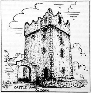 Fig. 16. General view of the tower-house at Castle Ward, Co. Down (c.1610). |
|
COUNTY FERMANAGH | |
| 50. AGHNAGLACK HORNED CAIRN. | About 1½ miles to the south west of Boho, near the Boho-Belleek road. |
| Known locally as the 'Giant's Grave', this is a very fine specimen of a double horned cairn, with claw-shaped forecourts at either end and two groups of burial chambers (Fig. 1). | |
| 51. BALLYREAGH HORNED CAIRN. | In the foothills about 3 miles to the west of Tempo. |
| A long cairn-some 100 feet in length-but with few of the original features now surviving. | |
| 52. KILTIERNEY CAIRNS AND STONE CIRCLE. | In the Kiltierney Deerpark, about 3 miles to the south west of Kesh. |
| (1) A multiple group consisting of a central cairn surrounded by a circle of 22 smaller cairns. Two of the six large stones on the central cairn are carved with devices of the Bronze Age period. (2) An incomplete stone circle, standing on a raised platform with seven large boulders (approximately 5 ft. by 3 ft. by 3 ft.) and one small stone. One of the large stones is isolated from the others and contains a bullaun. (3) Friar's Walk. This grass-grown track surrounding the multiple cairn group on two sides is connected by tradition with the Cistercian monks. |
|
| 53. KILLADEAS SCULPTURED STONES. | In Killadeas Graveyard about 7 miles to the north of Enniskillen on the Kesh road. |
| There are three sculptured stones: (1) The Bishop's Stone, probably ninth or tenth century work, with a human face and interlaced pattern carved on the west side. On the south side is carved an abbot or bishop with a crozier and bell. (2) A stone with a cross and traces of an Irish inscription carved on the front, and with cup marks on the back. (3) A stone with a small Greek cross inscribed on it, and two cut underneath. |
|
| 54. LISNASKEA CROSS. | In the town of Lisnaskea. |
| This cross, which stands in the corn and potato market facing the main street, consists of an ancient shaft and base surmounted by a comparatively modern cross. The sculpture on the east face of the shaft represents the Fall of Man, while the west face is ornamental. | |
| 55. BOHO CROSS. | In the Roman Catholic Churchyard in Boho. |
| The shaft and base of a high cross, with figure sculpture of the late ninth or early tenth century. | |
| 56. TEMPLENAFFRIN CHURCH. | About 1 mile to the east of Belcoo. |
| This church formerly served as a chapel of ease in the medieval parish of Cleenish. There is a partition wall at the west end which, perhaps, was the priest's house. The walls stand on a plinth. Near the church is a fine bullaun stone. |
|
| 57. DERRYBRUSK CHURCH. | About 4 miles to the south east of Enniskillen. |
| The ruins of this church (59 ft. by 29 ft.) are on an early ecclesiastical site and have one or two unique features. The west gable contains two small square-headed windows -- one above the other, while at the west end of the south wall are four square-headed windows, two above and two below. This and other features suggest that there may have been a second storey. | |
| 58. CORNASHEE MOUNT. | ½ mile to the north of Lisnaskea. |
| A large mound, apparently of piled stone covered with grass, 100 feet in diameter, and rising steeply. There is a cairn-like pile of stones on the top. It is thought that at one time it was an inauguration place of the Maguires. It has the appearance of a motte, without a ditch, but as it lies so far west it cannot be accepted as such without further evidence. | |
| 59. ENNISKILLEN CASTLE AND WATER GATE. | In the town of Enniskillen. |
| The earliest mention of a castle in Enniskillen was in 1439 when it is recorded that Maguire was taken prisoner in his own castle. The castle was besieged and captured by the English towards the end of the sixteenth century. After varying fortunes, during which the castle was captured and re-captured, it finally came into the charge of Captain William Cole in the early seventeenth century. The original bottom storey of the keep still remains, with the surviving large tower probably representing the 15th century castle, but the upper storeys have been largely re-built for use as a barrack. The remarkably fine Water Gate was built, probably in the 1580s, for a Maguire. | |
| 60. CROM CASTLE. | 4 miles to the south west of Newtownbutler. |
| Not to be confused with the more modern Crom Castle, this structure was built in 1611 by Michael Balfour, Lord of Mountwhaney. It was besieged in the wars of 1689-90, and later -- only in the eighteenth century -- was accidentally destroyed by fire. Only the outer wall of the bawn and two of the flanker towers now remain. | |
| 61. CREVINISH CASTLE. | On the shores of Lower Lough Erne about 2 miles to the south west of Kesh. |
| A Plantation castle built by Thomas Blennerhassett in the early seventeenth century (before 1618). Two storeys and a half still remain, with a square turret and loopholed windows at the north east corner. | |
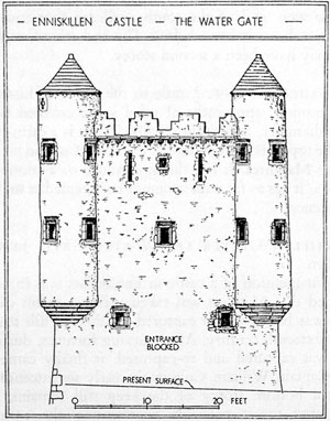 Fig. 17. Elevation of the outer face of the late sixteenth century Water Gate at the Maguire Castle of Enniskillen. |
|
| 62. TULLY CASTLE. | On the shores of Lough Erne 5 miles to the north of Monea Castle. |
| An early Plantation castle, which was surrendered to Captain Rory Maguire in 1641. It was burned by him and the majority of the English garrison massacred. A considerable portion of the castle still remains, including a large room on the ground floor with a vaulted roof and the main hall overhead. It appears that the castle originally had only two main floors with a spiral stair between. |
|
| 63. MOYLEHID PASSAGE GRAVE. | On the eastern summit of Belmore Mountain, 2½ miles north west of Letterbreen Creamery. |
| A late Neolithic monument containing a cruciform burial chamber, excavated in 1894. Cremated and uncremated bones were found, together with beads, a richly decorated urn and three cists. (Plate 2). | |
COUNTY LONDONDERRY | |
| 64. LOUGH ENAGH CRANNOG. | About 2½ miles to the north east of Londonderry near the coast road to Coleraine. |
| The crannog is on Rough Island, one of the two islands in Lough Enagh. An excavation has yielded finds typical of Neolithic, Bronze, and Iron Age periods. The medieval occupation was on the other island. | |
| 65. CREVOLEA DOLMEN. | Near the village of Blackhill, about 6 miles to the south of Coleraine. |
| The large basalt capstone, which is estimated to weight nearly 40 tons, originally rested on four pillar stones, but two of these were removed in the eighteenth century. | |
| 66. WELLGLASS CAIRN. | At Limavady Waterworks, about 4½ miles to the north east of Limavady. |
| This cairn, with a double-chambered grave and a double-portal entrance, was excavated in 1936, yielding Beaker and Bronze Age pottery. This was the first recognised evidence of Beaker pottery in Ireland. | |
| 67. MONEYDIG CAIRN. | At Moneydig Cross-Roads, about 3 miles to the east of Garvagh. |
| This dolmen, better known by it local name, 'Daff Stone', stands five feet high and has a large capstone, but, unlike most ancient grave structures, is covered by small cairn stones and soil. | |
| 68. TAMLAGHT DOLMEN. | About ½ mile to the west of Coagh and about 4 miles to the east of Cookstown. |
| An unusually fine dolmen, standing 12 feet high, with a huge quartzite capstone supported by six basalt uprights -- two of which have moved slightly from their original positions. | |
| 69. CORNACLERY ROUND CAIRN (BALLYDULLAGHAN). | About 3 miles to the south of Garvagh. |
| A large cairn on a small height. Excavated in 1939, the cairn yielded the inhumed skeleton of a Beaker man in the large cist, with evidence of Bronze Age cremations. | |
| 70. CLADY CUP AND RING MARKED STONE. | About ¼ mile to the north of Loughermore Bridge on the road from Claudy to Limavady and about 5 miles from the former. |
| This stone, the only one of its kind in Northern Ireland, was found under the turf bog. The cup and ring marks are still quite clear. | |
| 71. DUNGLADY FORT. | Near the village of Culnady about 5 miles' to the south west of Kilrea. |
| This triple-ringed fort is one of the largest and best-preserved earth forts in Northern Ireland. All but the central enclosure is now overgrown and nearly impassable (Plate 4a). | |
| 72. DAISYHILL (DRUMCEATT). | In Roe Park Estate about 1 mile to the south of Limavady. |
| Said to be the site of the sixth-century Convention of Drumceatt, where the rights and duties of poets were determined in the presence of Aedh, High King of Ireland, and a gathering of lesser kings, nobles and clergy, including St. Columcille. | |
| 73. GORTNAMOYAN INAUGURATION STONE. | About 3 miles to the west of Garvagh, on the edge of a recently-planted forest. |
| Known locally as the 'Giant's Track' or 'St. Adamnan's Footprints'. St. Adamnan was the patron saint of the district, and these footprints are carved out of the basaltic rock. It was customary for the king or chief to stand in the footprints during the ceremony of inauguration. | |
| 74. SAINT PATRICK'S STONE. | In the garden of Belmont House, Londonderry, close beside the Culmore Road. |
| This large block of stone embedded in the ground seems to be an inauguration stone since it has two footprints clearly cut near the centre (see also No. 73). It may be the stone blessed by St. Patrick when he visited Aileach. | |
| 75. DUNALIS SOUTERRAIN. | At the Coleraine and Portstewart Waterworks, about 3½ miles to the south west of Coleraine. |
| A large, three-chambered structure with the only known Ogham stone in County Londonderry built into the roof (Fig. 6). | |
| 76. BALLYWOOLEN SOUTERRAIN. | Close by a mill about 1 mile to the south east of Castlerock. |
| A typical example of local souterrain readily accessible, with a small, straight passage. Excavation has yielded flints, ox bones and stone axes. | |
| 77. BALLINTEMPLE SOUTERRAIN. | About 3 miles to the west of Garvagh. |
| This rock-hewn souterrain was cut ·out of the softer inter-basaltic layer and consists of six chambers -- 9 feet underground -- connected by narrow passages. | |
| 78. BALLYCAIRN MOTTE AND BAILEY. | About 1½ miles to the north west of Coleraine (on the west bank of the River Bann). |
| The motte is one of a chain of earth mounds on both banks of the river, and is of Norman construction. | |
| 79. TAMLAGHTARD HOLY WELL. | Beside the ruins of Tamlaghtard Church, about ½ mile to the east of Bellarena Railway Station. (Bellarena is about 12 miles from Coleraine on the coast road to Londonderry). |
| Bishop Aidan's Well (Tober Espueg Aiden) and tomb are still a resort for pilgrims. | |
| 80. BRACKFIELD CASTLE. | On the Claudy-Londonderry road, about 3 miles from the former. |
| Formerly a 'strong house' of the Skinners' Company, the 62 feet square bawn walls remaining are in fair state of preservation. At the north west corner is a flanker tower, 12 feet high, and at the opposite corner the remains of another (Fig. 12). | |
| 81. SALTER'S CASTLE. | On the shores of Lough Neagh, about 2 miles to the south of Ballyronan. |
| This, like Brackfield, is a good example of a 'strong house' built under the London City Companies' plantation, about 1619. The bawn has round flanker towers at opposite corners, and original loops are preserved. The house appears to have been enlarged later in the seventeenth century (Fig. 12). | |
| 82. DUNGIVEN CASTLE. | In the town of Dungiven. |
| The castle, built in the early seventeenth century by the government, was originally known as the King's House, and came into the possession of the Skinners' Company when the lands in this area were divided between the London Companies. It suffered severely through the ages, and now only the sandstone walls on the east and west sides of the original bawn still stand, together with a few of the arches which carried the defence platforms. | |
| 83. TIRKANE SWEAT HOUSE. | About 2½ miles to the north west of Maghera, near Lough Bran, and the ruins of Killelagh Church. |
| A well-preserved rectangular structure built against the side of the hill. The roof is of flat stones with a small chimney hole in one corner, and the floor is paved with stones. These sweat houses are the primitive forerunner of the modern Turkish Baths (which are, indeed, known in Germany as 'Irish Baths'). |
|
COUNTY TYRONE | |
| 84. LOUGH FEA MOTTE. | On a promontory jutting into Lough Fea, near Spawell Bridge on the tertiary road which skirts the west shore of the Lough and joins the B162 Cookstown to Draperstown road just south of the lake. |
| A rectangular mound, presumably of native Irish construction, since it is well beyond the Anglo-Norman pale. Probably a local imitation of a Norman motte, perhaps by an O'Neill of Tyrone. | |
| 85. CARNAGAT CAIRN. | To the west of Ballyness Mountain, midway between Fintona and Fivemiletown, and about 4 miles from each. |
| A circular cairn (about 12 feet across) of small, rounded stones, enclosing a horseshoe shaped chamber 7 feet in diameter. | |
| 86. SESSKILGREEN CHAMBERED GRAVE. | About 2 miles to the north west of Ballygawley in the Clogher Valley. |
| A roughly circular chamber. The inner face of several of the uprights was carved, but carving of concentric circles and other ornaments can now be distinguished on only one of the back stones (Fig. 3). | |
| 87. ISLAND MACHUGH CASTLE ON CRANNOG. | On a small island in Lough Catherine at Baronscourt. |
| The castle stands on a crannog constructed in Neolithic times and occupied through the Bronze Age. It was extended in the Early Christian period and used again in the later Middle Ages and sixteenth century. The keep measures 15 feet by lit feet with walls 3 feet thick. | |
| 88. CLOGHER CROSSES. | In the Cathedral graveyard at Clogher. |
| Two wheel-headed crosses with details of boss and interlaced decoration well preserved. They seem to be the only surviving remains of stone from the period when Clogher was an important diocesan centre in pre-Norman times. | |
| 89. BENBURB CASTLE. | A few hundred yards to the south of the village of Benburb, which is about 4 miles to the west of Moy. |
| The castle, a four-sided enclosure with corner towers, was built by Lord Wingfield c.1615 on the site of a castle or blockhouse of Shane O'Neill. It stands on a bluff above the river, and the curtain walls and loopholes are well preserved. The north west rectangular tower, in which are several cruciform loopholes, rises to a gable with remains of a chimney stack. On one of the corners is a round tower with a spiral stair. | |
| 90. DERRYWOONE CASTLE. | About ½ mile to the north east of Baronscourt, near the town of Newtownstewart. |
| This is an L-shaped gabled house of the early seventeenth century with two distinctive features-a fine Scottish corbelled staircase turret in the re-entrant angle, and a round tower in one corner. The shell of the building is fairly complete (Fig. 11). | |
| 91. SPUR ROYAL CASTLE. | At the western end of the town of Augher. |
| A square, three-storied plantation castle, without turrets, but with a triangular tower projecting in the middle of each side. The original structure, built by Lord Ridgeway about 1615, was burned in 1689 and thoroughly restored in the early nineteenth century, at which time the north front (enclosing the older north wall) was added. Nearly all the windows were renewed, although there are traces of a large rectangular window in the west wall which may be original. | |
| 92. ROUGHAN CASTLE. | About 2 miles to the south west of Stewartstown. |
| The castle, built in 1618 by Sir Andrew Stewart, preserves details of Scottish corbelling (found also in Monea Castle, Co. Fermanagh). It is a square three-storied castle with round towers at the four corners and open fireplaces on the first and second floors. (Fig. 11 and Plate 8b). | |
| 93. NEWTOWNSTEWART CASTLE. | In the town of the same name. |
| This castle, built in the early seventeenth century by Sir R Newcomen, fell into the hands of insurgents in 1641, and was burned in 1689 by order of James II on his return from the siege of Londonderry. The structure is a good example of an early seventeenth century house with crow-stepped gables showing probable Scottish influence. |
|
| 94. CADIAN SWEAT HOUSE. | About 6 miles to the south west of Dungannon. |
| An elliptical building, 4 ft. 6 ins. by 5 ft., with walls of dry stone 5 ft. high, and a triangular opening for a flue (see also No. 83). | |
| 95. AUGHENTAINE CASTLE. | About 2½ miles north of Fivemiletown. |
| A rectangular planter's castle, built in 1618 by Sir William Stewart. The remains of three storeys are visible, with a fourth in the west gable. Angle turrets feature Scottish-type corbelling, as at Derrywoone (90) and elsewhere. Bombarded and burnt by Sir Phelim O'Neill in 1642, it was not subsequently restored, but still stood foursquare until 1935, when the south wall collapsed due to settlement. |
|
| 96. CASTLEDERG CASTLE. | In the village of the same name, on the north bank of the River Derg, about 200 yards west of Castlederg Bridge. |
| The remains of a large bawn built by Sir John Davies about 1610. Part of a flanking tower survives at the south-east corner, but the south-western one has disappeared. The evidence of a motte here suggests the presence of an earlier castle on the site. | |
PLATES AT BACK