
ENTRANCE OF WILLIAM III TO BELFAST.
One of the disputed points about the entrance of William III to the town of Belfast on Saturday, 14th June, 1690, is by which Gate did he enter? Benn says :--
"The belief always has been that the entrance was made by the North Gate, at the top of what was then known as North Street, close to the present John Street. It was called by distinction the North Gate, and is twice mentioned... as the point at which or near which the King was met and received by the town officials and the episcopal clergy, but it is also twice mentioned... that he crossed the Strand, the entrance into the town from which direction would have been the Strand Gate at Mary Street, a street not now existing. It is beyond the writer's power to reconcile these two apparent contradictions. It is hardly possible to conceive that both gates could have been called indifferently by the same title."
History of Belfast, p.. 181
The North Gate, as mentioned by Benn at the top of North Street and John Street, was erected by Colonel Arthur Chichester, afterwards 1st Earl of Donegall, in 1642, as appears in the Corporate Records :--
"24 die Junii 1642.
"It is agreed that for the finishinge of the Rampier about the Towne all such as have not paid their former rates shall presently pay them or bee distrayned for them. And that for a further addition to that worke The Lord Chichester Officer in his Lorps behalfe is content to make the Drawe Bridge and pallisadoes and the Towne is content to give a thousand dayes worke with a man. And it is desired that in a further addition to soe necessary a worke that Collonell Chichester will take Order that each Companye of his Regimt may worke three score dayes to the said worke. And that hee will appointe their sevrall officers to see them p'forme itt."
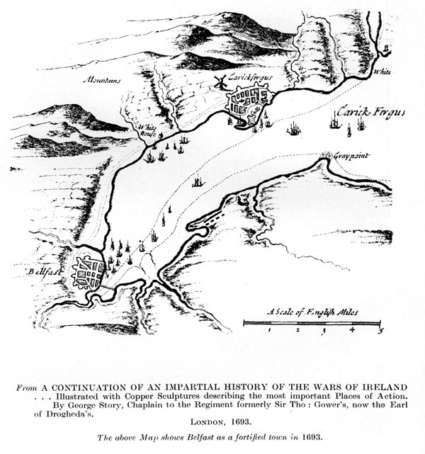
According to Isaac Ward, this new erection "was called the North Gate and was not many years in existence." That opinion is confirmed by a coloured plan of Belfast in the British Museum, K. 51.39, drawn about 1680, which shows a gate at the top of North Street, but no indication of a gate at the Strand. Phillips' Map of 1685, on the other hand, omits any indication of a gate in North Street but shows an elaborate structure in the form of a gate near the Strand.
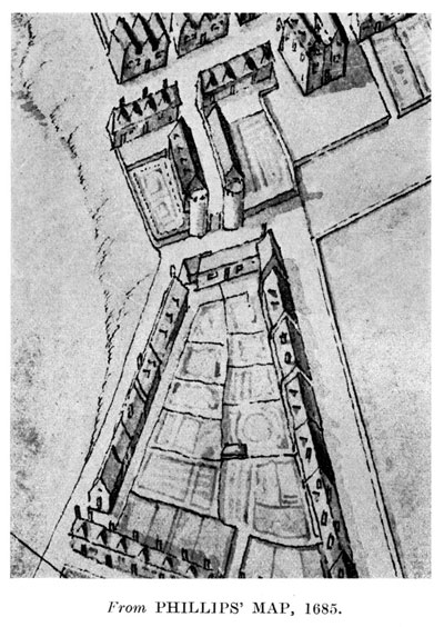
In the foreground of the above map are the Fore Plantation, towards the east, and the Back Plantation, towards the west. The Strand Gate is at the north end of Mary Street alias Cow Lane, which leads southwards to Broad Street alias Waring Street. The tidal waters ebbed and flowed over the Strand which formed the east boundary of the town.
It was across that Strand that William III drove with Schomberg from White house, according to a broadsheet printed and published in London only a few days after the King reached Hillsborro. In An Exact Account of His Majesty's Progress from his First Landing in Ireland till his Arrival at Hillsborough (London 1690) the writer says :--
"The General met the King at Four of the Clock, who was pleased to alight, and go into his Coach, attended only with one Troop of Horse, and a few Gentlemen, and immediately drove over the Strand hither."
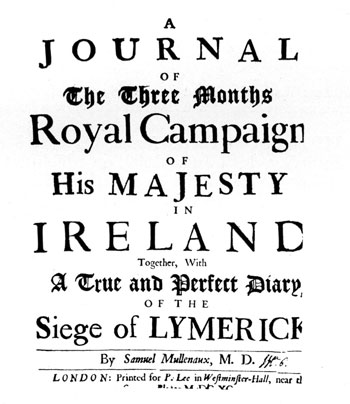
A similar description is given in a pamphlet of 28 pages in double columns, written by Samuel Mullenaux, M.D., entitled A Journal of the Three Months Royal Campaign etc. --
"At the White-house, half-way betwixt Carrickfergus and Belfast, His Majesty was met by the Duke of Schonbergh in his Coach and Six Horses; the King was pleased to alight, and go into the Duke's Coach, attended only with one Troop of Horse and a few Gentlemen, and immediately drove over the Strand to Belfast."
The similarity of the language and the subject-matter in An Exact Account and Mullenaux's Journal indicates that the two were written by the same person and that An Exact Account was the first instalment, published anonymously, as underneath.
G. W. Story, in An Impartial History of the Affairs of Ireland, London 1691, gives the following account :--
"on the 14th, being Saturday, he landed at Carrickfergus about 4 a'clock in the Afternoon. His Majesty went through part of the Town and viewed it; and notice being given immediately to the General... his Grace went in his Coach, with all speed, to wait on the King; Maj. Gen. Kirk and several Officers that were there expecting the King's landing, attended the Duke; his Majesty was met. by them near the White-House, and received them all very kindly, coming in the Duke's Coach to Belfast.. "
The following account appears in the Corporate Records, under the heading Juratio Superiorum :--
"in wch yeare ye fourteenth day of June one thousand six hundred and ninety his most gracious and Puissant Majtie Kinge William Landed at Carrickfargus & that same day his Majtie and Duke Sconberge in a Coach came to Bellfast... was received at ye entrance of the Towne by the Soveraigne Burgesses and Inhabitants of the Corporacon and that part of the Armey then in their best formallitys with acclamacions of great joy and rejoyceing and was conducted to ye Castle where he graciously received the Soveraigne & Burgesses where ye Soveraigne upon his Knee humbly presented the Rod of authority wch his Majtie received bidding him rise and gave it back againe and ye Soveraigne againe kneeling presented an addresse of the Soveraigne Burgesses and Comonality wch was read before his Majtie and after received it and the Kinge put it in his Pockett and then the Soveraigne and Burgesses had the honor of Kissing his Majties hand."
Richard Dobbs in A Brief Description of the County of Antrim (1683) says :--
"At Low Water the strand may be rid to BeIfast, though for the most part there is no more of the strand made use of than from Belfast to Whitehouse."
William III landed at Carrickfergus between 3 and 4 in the afternoon of Saturday, 14th June, 1690, on which date High Water was 12.05 local time, as calculated by my friend, Mr. C. E. I. Wright, and confirmed by the Hydrographer to the Admiralty.
Let us now look at the formation of the Fore and Back Plantations. In 1670 Arthur, 1st Earl of Donegall granted a lease to William Waring of four half burgage shares on the north side of Broad Street, opposite the present Ulster Bank, with a covenant "to plant and preserve 150 young Oak, Ash, Elm, or Beech trees." That lease was renewed by the 4th Earl on 17th August, 1716, to Westenra Waring, son of the original lessee, the parcels of which are :
"the moiety of the holding at the lower end of Broad Street or Waring Street, called the Eight Pearch and all the strand northwards from Waring Street end to the Mile Water River towards Carrickfergus and bounded eastward with the Channell of the Laggan River leading to the Dock and Key of Belfast."
William Waring's lease of 1670 led to the planting of the Fore and Back Plantations, of which Benn says :--
"They were built by Mr. Waring and are sometimes called in old documents Waring's Plantations. They were the building speculations of the seventeenth century. The Fore Plantation was much longer and in 1792 ran from Waring Street, in the line of the present Victoria Street, to the shipyard. The Back Plantation was behind it."
Benn here falls into two serious mistakes. Waring's Plantations were not a building speculation but were planted in compliance with the covenant in his lease, inserted by the 1st Earl with a characteristic desire to improve the amenities of the town. The Fore Plantation was not "in the line of the present Victoria Street" but in the line of Corporation Street which, if continued in a straight line, would cross Arthur Square.
There is ample evidence that the covenant to plant the young trees was carried out inside a year from the date of the lease. In the Corporate Records there appear the Minutes of "an Assembly of the Sovereigne and Burgesses of this Burrough of Belfast", of which William Waring was Sovereign, held on 28th September, 1671, when it was ordered to repair
"the course of the backwater belonging to the Miln and the same to be brought to the Rampyer nere the north gate and from thence on the backside of the Noth Streete as low as the house of Henry Thetford in the sayd Street and from thence all along to the present Soveraignes new plantacion. And the same to be repayred and maintained from time to time at the cost and charges of the Inhabitts of the said North Streeet."
Although there is no direct evidence, I think it may be assumed that William Waring built the Strand Gate as an entrance to and from the Plantations which he formed in 1670. Mary Street alias Cow Lane was on the ground leased to him by Arthur, 1st Earl of Donegall and, from its ornamental character, as shown on the 1685 Map, it would seem to have been an adjunct to the Fore and Back Plantations rather than a means of defence against an invading enemy, such as the so-called North Gate which was erected in 1642 when protection was considered to be a necessity. The North Gate had disappeared according to Phillips in 1685 and, assuming he was correct and, at the same time, taking into consideration that the Corporate Records does not specify the particular gate, I think we may safely conclude that "ye entrance of the Towne," by which King William III entered Belfast on 14th June, 1690, was the Strand Gate, after driving from "White house" across the Strand, and thence through Mary Street alias Cow Lane, Broad Street alias Waring Street, Bridge Street, High Street and entered the Castle Gates on the west side of Cournmarkett, as the name is spelt in a lease of 1692.
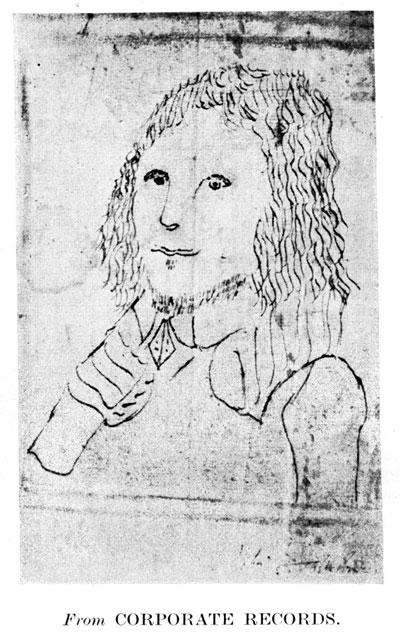
Captain R Leathes who, as Sovereign of Belfast, presented "ye Rod of authority" to King William III, was one of the most important and enterprising of the Burgesses and the only one whose portrait appears in the Corporate Records. Elected as a Free Burgess, 26th Augnst, 1669, he was a Justice of the Peace for the County of Antrim, Seneschall of the Mannor of Belfast; Sovereign of Belfast from Michaelmas 1686 to 1690: 1697: and 1714; Resigning as a Burgess in 1717, he was elected Constable of the Castle on 29th June, 1717. He, in conjunction with George McCartney, niger, or Black George McCartney, carried out the Water Supply in 1678. He also, in conjunction with Captain David Smith, introduced the manufacture of Pottery, closely resembling Delft, and is described as "a man of great ingenuity" by Sachaverell, who visited Belfast in 1698. An Oak Punchbowl bears the inscription :--
"Presented to R Leathes, Sovereign of Belfast, and Agent to the Earl of Donegall, in the year 1690, it having been in the Donegall Family for upwards of 100 years previous."
Potthouse is a rare and obscure word and is defined by the Oxford Dictionary as "a house where pottery is made" and gives as an instance of its use in the London Gazette, 1697: "A very convenient brick house to be let having a Potthouse belonging to it and a very fine yard for washing of clay." Sacheverell, who visited Belfast, in 1698, says :--
"The new Pottery is a pretty curiosity, set up by Mr. Smith, the present Sovereign, and his predecessor, Captain Leathes, a man of great ingenuity."
Ten years later, Sir Thomas Molyneux, a distinguished Dublin Physician and Fellow of the Royal Society, visited Belfast in August, 1708, and has left on record :--
"Here we saw a very good manufacture of earthenware which comes nearest Delft of any made in Ireland and really is not much short of it. 'Tis very clean and pretty, and universally used in the north, and I think not so much owing to any peculiar happiness in their clay but rather in the manner of beating and mixing it up."
Molyneux does not mention a Potthouse but in a Marriage Settlement, bearing date 28th May, 1709, there are the words :--
"Portions of the Governour's Fields or Park... the Potthouse... all situate on the N side of Broad Street."
That is confirmed by the words in a deed, bearing date 14th March, 1714:--
"Part of Buller's Meadow and the Potthouse or old Soaphouse."
The word "old" is there used in the sense of "formerly", and the position of the soaphouse, which apparently had been converted into a potthouse, can be approximately located by Maclanachan's Map of 1715, which shows "Soap lean" on the eastern side of North Street and running in a south-east direction from what appears on the map as "atch ors walk". The omitted letters are due to a defect on the map, but by adding what, probably, are the omitted letters, we get "Batchelors walk", a variant of the well-known "Lover's Walk."
The Potthouse was still in existence in 1722, and a lease, bearing date 6th September, 1722, refers to
"tenements... situate on the N. side of Broad Street... the Potthouse now in possession of Thomas Banks as Executor of Richard Hodgkinson..."
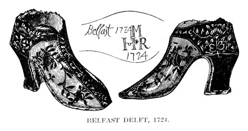
Benn, in describing the above illustration, says :--
"The article represents a lady's boot in strong delf ware; it is two inches in height, making the opening of the middle of the sole a clear space of an inch and a half high, and therefore very large in proportion to the length of the object. It is a true representation of a lady's boot of the period, and perhaps not very materially differing from that in use at the present time, so much objected to as being prejudicial to health. It is of a dark blue on a white ground, plentifully ornamented with flowers, blue in colour on the white ground and white on the blue, and was most probably one of the artistic articles of the day intended as an ornament of the mantlepiece. In such situation it may have held flowers, the interior, being of course, open for that or some similar purpose. The inscription, however, is that which alone gives it value, the date 1724 being twice marked, with the initials M.H.R. and the word Belfast at the beginning. All these are upon the sole and burned in, and the genuineness of the article cannot be doubted. It proves the existence of the manufacture for twenty-six years (1698-1724). So far as known it is unique, though it is possible that other specimens of the early pottery work of Belfast may yet be found in the town. The curious relic here described is the property of a lady in Belfast who states that it belonged to her grandmother."
But the pottery seems to have been discontinued about the middle of the 18th century, as in a deed, bearing date 13th January, 1755, there are the words :--
"Part of Warring's Plantation, containing three acres, whereon... and a Potthouse were formerly built."
The industry was continued towards the end of the 18th century, and an advertisement in 1792 includes the words :-- "Pottery, Ballymacarett, near Belfast", the position of which is shown on Williamson's Map of 1791, and thereon called "China Manufactory".
An interesting Chart appeared in a volume entitled Great Britain's Coasting Pilot by Captain Greenville Collins, Hydrographer in ordinary to the King and Queen's most Excellent Majesties which was printed in London in 1693 and is the first published Chart of Belfast Lough. It supplies much interesting historical information of which the following may be mentioned :--
| CARRECK-FERGUS King WILL: Landed 1690. | White house here K Will : Army Landed |
| A Prospect of CARRECK-FERGUS being the Place where King William landed in Ireland |
|
| A. The King in the Mary Yacht Capt. Collins. | |
| B. Prince George in the Heneretta Yacht Capt. Sanderson. | |
| C. The King goeing a Shoare in Sr Clo: Chouells Barg. | |
| D. Sr C. Shovell Rear Admll of the Blew in the Monk with his Squadron. | |
| Bonfiers on the Shoare. | |